lancaster LA7 Postcodes
Spending a fortune on conveyancing?

Compare instant, low-cost online quotes from trusted conveyancing solicitors.
Backed by experts, our no-obligation service searches through the best conveyancing quotes on the market to save you time and money.
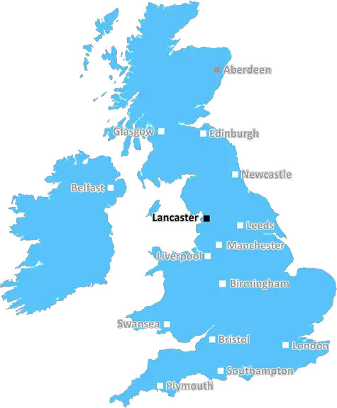
Lancaster (LA7)
The LA7 postcode area is located in the Lancaster postcode town region, within the county of Cumbria, and contains a total of 252 individual postcodes.
There are 34 electoral wards in the LA7 postcode area, including Ambleside, Askam-In-Furness, Barrow-In-Furness, Broughton-In-Furness, Carnforth, Coniston, Dalton-In-Furness, Grange-Over-Sands, Kendal, Kirkby-In-Furness, Lancaster, Millom, Milnthorpe, Morecambe, Sedbergh, Ulverston, Windermere which come under the local authority of the South Lakeland Council.
Combining the whole postcode region, 32% of people in LA7 are classed as having an AB social grade, (i.e. 'white-collar' middle-upper class), compared to 27% across the UK.
This does not mean that the people of LA7 are wealthier - or higher class - than average, but it can be an indication that the area may be prospering and desirable to live in.
The LA7 postcode covers the small area on the north east side of Lancaster, alongside the River Lune. It is mostly rural, with the River Lune being the main geographical feature of the area, and with most of the housing being located within a few miles of the river.
The landscape in this postcode is composed of rolling hills and a patchwork of small fields that are primarily used for either pasture or arable farming. The area is very popular with walkers, who enjoy the breathtaking views, and cyclists who take advantage of the narrow lanes and well-surfaced tracks leading to places of interest in the area.
The eastern side of the postcode is made up of a variety of small towns and villages. Kirkby Lonsdale, Arnside and Silverdale provide ample opportunities for visitors to enjoy a range of outdoor activities, including exploring the nearby ancient woodlands. In addition, Silverdale has become a popular spot for birdwatchers, as it is home to a variety of species including Bramblings, Siskins and Lapwings.
The small villages of Caton and Galgate are located further south and have a more suburban feel. There are plenty of amenities on offer in this area, including a variety of shops, pubs, and recreational facilities such as parks.
The LA7 postcode also contains a number of traditional market towns, such as Halton and Hornby, which contain historical buildings such as the Halton Castle. Visitors are drawn to these locations for their quaintness, as well as for their retail offerings.
Finally, LA7 is home to several large employers and provides a range of excellent educational opportunities for locals. This includes a variety of different secondary schools and colleges, as well as the University of Lancaster, which is particularly well known for its research and postgraduate provision.

Demographics
Cumbria

LA7 is located in the county of Cumbria, in England.
Cumbria has a total population of 497,900, making it the 41st largest county in the UK.
Cumbria has a total area of 2612 square miles, and a population density of 73 people per square kilometre. For comparison, Greater London has a density of 5,618 people/km2.
| Outward Code | LA7 |
| Postal Town | Lancaster |
| MSOA Name | South Lakeland 011 |
| LSOA Name | South Lakeland 011E |
| County | Cumbria |
| Region | Cumbria |
| Country | England |
| Local Authority | South Lakeland |
| Area Classification | Mainly Rural (rural including hub towns >=80%) |
LA7 Electoral Wards
The postal region of LA7, includes the local towns, villages, electoral wards and stations of:
Dig even deeper into the LA7 postcode by clicking on a postcode below:
Click on an outward postal code below for more information about the area. Each 'outward' postcode give you a comprehensive list of all postcodes within the outward code area (LA) and estimated address.
Click on an 'outward' code for more information. For example, the outward postcode page 'EC2M' will give you an alphabetical list covering all postcodes located in the region, from 'EC2M 1BB' through to 'EC2M 7YA'.
Chris H
Wednesday, April 10, 2024
We don't have any views of LA7 right now. If you live in LA7 or have visited it, please help us to help others by telling others what you think of this neighbourhood.
Add your view of LA7
People need your local expertise. If you live in LA7 or have first-hand knowledge of the neighbourhood, please consider sharing your views. It's completely anonymous - all we ask is for your initials.
Please tell us what you like about the LA7 postcode area, what you don't like, and what it's like to live or work here.
| LOCAL AMENITIES | |
| FAMILY FRIENDLY | |
| PARKING | |
| GREEN SPACES |
From the Postcode Area blog

Deciphering Crime Rates - a Deep Dive Into UK Postcode Analysis
Ever wondered about the crime rate in your UK postcode? You're not alone. We've dug deep into the data, uncovering trends and patterns that'll make your head spin.

Death of the High Street?
The BBC reports that despite councils' attempts to kurb them, the UK's high streets have seen a huge growth in fast food outlets. Could this mark the death knell for the Great British high street, and what can we do about it to halt its decline?

Discrimination by Postcode
You really couldn't make it up, could you? Some of the country's most vulnerable people are missing out on their weekly £25 Cold Weather Payment, just because the system that's in operation is discriminating against them because payments are based on postcode, rather than geographic location.

The Redesign is Underway
Well, the current website was absolutely in dire need of a good redesign - from the ground up. So I set out to pull it all apart and get it up and running again to become the most comprehensive guide to every postcode in the UK. And it's been a long, tough job from start to finish - and quite possibly the biggest project I've ever undertaken.
SOCIAL GRADES
According to census records, 32% of people here have a social grade of AB (highest), compared to the national average of 27%.