carlisle CA26 Postcodes
Spending a fortune on conveyancing?

Compare instant, low-cost online quotes from trusted conveyancing solicitors.
Backed by experts, our no-obligation service searches through the best conveyancing quotes on the market to save you time and money.
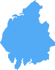
Carlisle (CA26)
The CA26 postcode area is located in the Carlisle postcode town region, within the county of Cumbria, and contains a total of 121 individual postcodes.
There are 11 electoral wards in the CA26 postcode area, including Alston, Appleby-In-Westmorland, Beckermet, Brampton, Carlisle, Cleator, Cleator Moor, Cockermouth, Egremont, Frizington, Holmrook, Keswick, Kirkby Stephen, Maryport, Moor Row, Penrith, Ravenglass, Seascale, St Bees, Whitehaven, Wigton, Workington which come under the local authority of the Copeland Council.
Combining the whole postcode region, 22% of people in CA26 are classed as having an AB social grade, (i.e. 'white-collar' middle-upper class), compared to 27% across the UK.
This does not mean that the people of CA26 are poorer than other areas, but it may give an indication that there are areas of deprivation.
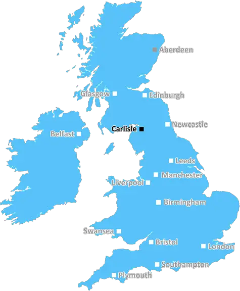
The CA26 postcode is situated in the Copeland borough of Cumbria, in North West England. It covers a wide area of the county, from the town of Whitehaven in the north to the villages of Broughton Moor and North Scale in the south.
The area encompassed by the postcode is full of picturesque scenery, particularly around the River Ellen. Some of the hills and mountains in the vicinity include Ennerdale Fell, Bannerdale Crags, Branstree, Sallows and Dent. All these locations provide stunning panoramic views across the surrounding area, particularly on a clear day.
The majority of the area in and around the CA26 postcode is rural. The towns of Cleator and Egremont are located in the north and south respectively, while other villages such as Parton and Beckermet can be found in between.
A variety of businesses are located in the postcode area; these include hotels, guesthouses, health services, engineering, retail, and technology. Whitehaven is home to the Cockermouth, Keswick and Penrith railway line.
The area is home to the Solway Coast, an Area of Outstanding Natural Beauty. This coastline stretches 27 miles and offers views of stunning vistas, wildlife, architecture and history. It is a popular area for those looking to enjoy a day or two out in the countryside.
The postcode is also home to the Sellafield nuclear site, owned by the Nuclear Decommissioning Authority. This is the most hazardous environmental site in the UK, with some of the radioactive waste said to date back to the dawn of the nuclear industry.
The postcode is also home to many diverse cultures; including both English and Scottish influences. There are a number of old market towns and fishing villages, as well as hidden hamlets, throughout the region, with a number of well-maintained houses in the area.
The CA26 postcode area has a rich history, being home to the Roundheads during the English Civil War, and the Lake District, which was dubbed a World Heritage Site by UNESCO in 2017. It has a wealth of festivals and events throughout the year, and is an ideal destination for those looking to explore and experience a unique and beautiful corner of England.

Demographics
Cumbria
CA26 is located in the county of Cumbria, in England.
Cumbria has a total population of 497,900, making it the 41st largest county in the UK.
Cumbria has a total area of 2612 square miles, and a population density of 73 people per square kilometre. For comparison, Greater London has a density of 5,618 people/km2.
| Outward Code | CA26 |
| Postal Town | Carlisle |
| MSOA Name | Copeland 004 |
| LSOA Name | Copeland 004I |
| County | Cumbria |
| Region | Cumbria |
| Country | England |
| Local Authority | Copeland |
| Area Classification | Mainly Rural (rural including hub towns >=80%) |
CA26 Electoral Wards
The postal region of CA26, includes the local towns, villages, electoral wards and stations of:
Dig even deeper into the CA26 postcode by clicking on a postcode below:
Click on an outward postal code below for more information about the area. Each 'outward' postcode give you a comprehensive list of all postcodes within the outward code area (CA) and estimated address.
Click on an 'outward' code for more information. For example, the outward postcode page 'EC2M' will give you an alphabetical list covering all postcodes located in the region, from 'EC2M 1BB' through to 'EC2M 7YA'.
Chris H
Sunday, April 14, 2024
We don't have any views of CA26 right now. If you live in CA26 or have visited it, please help us to help others by telling others what you think of this neighbourhood.
Add your view of CA26
People need your local expertise. If you live in CA26 or have first-hand knowledge of the neighbourhood, please consider sharing your views. It's completely anonymous - all we ask is for your initials.
Please tell us what you like about the CA26 postcode area, what you don't like, and what it's like to live or work here.
| LOCAL AMENITIES | |
| FAMILY FRIENDLY | |
| PARKING | |
| GREEN SPACES |
From the Postcode Area blog

Deciphering Crime Rates - a Deep Dive Into UK Postcode Analysis
Ever wondered about the crime rate in your UK postcode? You're not alone. We've dug deep into the data, uncovering trends and patterns that'll make your head spin.

Death of the High Street?
The BBC reports that despite councils' attempts to kurb them, the UK's high streets have seen a huge growth in fast food outlets. Could this mark the death knell for the Great British high street, and what can we do about it to halt its decline?

Discrimination by Postcode
You really couldn't make it up, could you? Some of the country's most vulnerable people are missing out on their weekly £25 Cold Weather Payment, just because the system that's in operation is discriminating against them because payments are based on postcode, rather than geographic location.

The Redesign is Underway
Well, the current website was absolutely in dire need of a good redesign - from the ground up. So I set out to pull it all apart and get it up and running again to become the most comprehensive guide to every postcode in the UK. And it's been a long, tough job from start to finish - and quite possibly the biggest project I've ever undertaken.
SOCIAL GRADES
According to census records, 22% of people here have a social grade of AB (highest), compared to the national average of 27%.