truro TR13 Postcodes
Spending a fortune on conveyancing?

Compare instant, low-cost online quotes from trusted conveyancing solicitors.
Backed by experts, our no-obligation service searches through the best conveyancing quotes on the market to save you time and money.
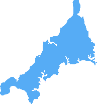
Truro (TR13)
The TR13 postcode area is located in the Truro postcode town region, within the county of Cornwall, and contains a total of 920 individual postcodes.
There are 111 electoral wards in the TR13 postcode area, including Camborne, Falmouth, Hayle, Helston, Isles Of Scilly, Marazion, Newquay, Penryn, Penzance, Perranporth, Redruth, St Agnes, St Columb, St Ives, Truro which come under the local authority of the Cornwall,Isles of Scilly Council.
Combining the whole postcode region, 19% of people in TR13 are classed as having an AB social grade, (i.e. 'white-collar' middle-upper class), compared to 27% across the UK.
This does not mean that the people of TR13 are poorer than other areas, but it may give an indication that there are areas of deprivation.
TR13 is the postcode for the Truro district of Cornwall, England. The district covers an area of approximately 177 square kilometres, and is home to the county's administrative capital, Truro. Its population is approximately 31,000.
The postcode area has three postal towns, each with its own postcode. These are Truro, Falmouth and Helston. All three are located within the district and are well-connected with small-scale public transport, including local buses.
TR13 is served by two main railway lines. The main line starts from Cornwall's largest town, Truro, and continues west towards Penzance. From there, three other lines, the Truro to Falmouth and Helston Line, the Truro to Redruth Line, and the Falmouth to St Austell Line, offer connections to the other towns within the TR13 postcode area.
The Truro district includes several tourist attractions as well as attractions related to Cornwall's culture and history. These include the Eden Project, the National Maritime Museum Cornwall, Truro Cathedral, the Royal Cornwall Museum, and St Michael's Mount. It has an impressive coastline, with small coves such as St Anthony's Cove, Towan Beach, and Perranarworthal Cove.
The economy of the district largely revolves around agriculture, with the remainder derived from the services sector. Truro is known for its traditional and independent shops, such as art galleries, boutiques and bric-a-brac stores. Falmouth boasts one of Britain's largest natural harbours, and among its attractions are Pendennis Castle and numerous antique and gift shops.
Finally, TR13's main educational establishments are Truro and Penwith College, Truro School, the University of Cornwall, and Truro and Falmouth Academy. This postcode area is served by several health care providers, including Royal Cornwall Hospital in Truro, the Royal Cornwall NHS Trust, NHS Kernow, and the Cornwall and Isles of Scilly NHS Foundation Trust.

Demographics

Cornwall
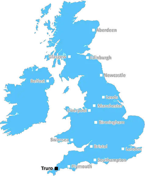
TR13 is located in the county of Cornwall, in England.
Cornwall has a total population of 556,000, making it the 40th largest county in the UK.
Cornwall has a total area of 1375 square miles, and a population density of 156 people per square kilometre. For comparison, Greater London has a density of 5,618 people/km2.
| Outward Code | TR13 |
| Postal Town | Truro |
| MSOA Name | Cornwall 072 |
| LSOA Name | Cornwall 072C |
| County | Cornwall |
| Region | Cornwall |
| Country | England |
| Local Authority | Cornwall,Isles of Scilly |
| Area Classification | Mainly Rural (rural including hub towns >=80%) |
TR13 Electoral Wards
The postal region of TR13, includes the local towns, villages, electoral wards and stations of:
Dig even deeper into the TR13 postcode by clicking on a postcode below:
Click on an outward postal code below for more information about the area. Each 'outward' postcode give you a comprehensive list of all postcodes within the outward code area (TR) and estimated address.
Click on an 'outward' code for more information. For example, the outward postcode page 'EC2M' will give you an alphabetical list covering all postcodes located in the region, from 'EC2M 1BB' through to 'EC2M 7YA'.
Chris H
Tuesday, April 9, 2024
We don't have any views of TR13 right now. If you live in TR13 or have visited it, please help us to help others by telling others what you think of this neighbourhood.
Add your view of TR13
People need your local expertise. If you live in TR13 or have first-hand knowledge of the neighbourhood, please consider sharing your views. It's completely anonymous - all we ask is for your initials.
Please tell us what you like about the TR13 postcode area, what you don't like, and what it's like to live or work here.
| LOCAL AMENITIES | |
| FAMILY FRIENDLY | |
| PARKING | |
| GREEN SPACES |
Local News Cornwall
Dad who fell off kayak nearly drowned in freezing water that 'felt like daggers'
The water was so cold it took his breath away and his body temperature dropped significantly
Cornwall LiveMeet the new landlords taking 'leap of faith' with pub that closed over rising costs
The popular St Austell Brewery-owned pub was closed for six months before exchanging hands recently
Cornwall LiveInside Cornwall's housing market as house prices finally drop from Covid madness
Cornwall remains in the grip of a housing crisis nonetheless
Cornwall LiveMan dies in Cornwall rush hour crash
A man in his 30s died and four people were taken to hospital following the crash near Quoit
Cornwall LiveA30 Cornwall closures hit again this week
A30 traffic in Cornwall will be affected by closure again this week and throughout the weekend, with diversions in place
Cornwall LiveFootage shows Storm Kathleen waves swamping unwisely parked car in Porthleven
It came amid heavy rain and winds of between 50 and 70mph
Cornwall LiveADVERTORIAL: Sensational St Loy's Cove house offers once in a lifetime opportunity
Now on the market, St Dellan has been owned by the same family since 1962
Cornwall LiveCornwall Council's vice-chairman says he's 'fed up' with number of potholes in St Austell
Conservative councillor Jordan Rowse said he's never seen so many potholes in his Cornish town and 'we need action now'
Cornwall LiveFrom the Postcode Area blog

Deciphering Crime Rates - a Deep Dive Into UK Postcode Analysis
Ever wondered about the crime rate in your UK postcode? You're not alone. We've dug deep into the data, uncovering trends and patterns that'll make your head spin.

Death of the High Street?
The BBC reports that despite councils' attempts to kurb them, the UK's high streets have seen a huge growth in fast food outlets. Could this mark the death knell for the Great British high street, and what can we do about it to halt its decline?

Discrimination by Postcode
You really couldn't make it up, could you? Some of the country's most vulnerable people are missing out on their weekly £25 Cold Weather Payment, just because the system that's in operation is discriminating against them because payments are based on postcode, rather than geographic location.

The Redesign is Underway
Well, the current website was absolutely in dire need of a good redesign - from the ground up. So I set out to pull it all apart and get it up and running again to become the most comprehensive guide to every postcode in the UK. And it's been a long, tough job from start to finish - and quite possibly the biggest project I've ever undertaken.
SOCIAL GRADES
According to census records, 19% of people here have a social grade of AB (highest), compared to the national average of 27%.