truro TR12 Postcodes
Spending a fortune on conveyancing?

Compare instant, low-cost online quotes from trusted conveyancing solicitors.
Backed by experts, our no-obligation service searches through the best conveyancing quotes on the market to save you time and money.
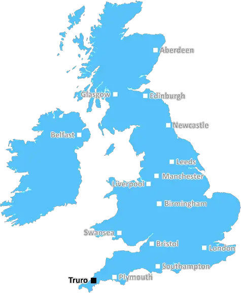
Truro (TR12)
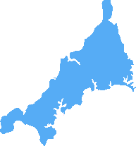
The TR12 postcode area is located in the Truro postcode town region, within the county of Cornwall, and contains a total of 484 individual postcodes.
There are 95 electoral wards in the TR12 postcode area, including Camborne, Falmouth, Hayle, Helston, Isles Of Scilly, Marazion, Newquay, Penryn, Penzance, Perranporth, Redruth, St Agnes, St Columb, St Ives, Truro which come under the local authority of the Cornwall,Isles of Scilly Council.
Combining the whole postcode region, 19% of people in TR12 are classed as having an AB social grade, (i.e. 'white-collar' middle-upper class), compared to 27% across the UK.
This does not mean that the people of TR12 are poorer than other areas, but it may give an indication that there are areas of deprivation.
TR12 postcode is located in the district of Truro in the South West of England. It covers an area to the east of the city centre, including parts of Truro, Malpas, Tregony, Rose and Treliske. The postcode is part of the Cornwall postal county, and the county itself is referred to as the 'Cornish Riviera' due to its diverse coastal scenery.
Residents of the TR12 postcode area can enjoy a wide range of amenities and attractions. There are nearby beaches and creeks, ideal for sunbathing, swimming, or taking part in watersports, as well as museums, gardens, parks, wildlife reserves, leisure centres and outdoor activities. This means that TR12 is a great destination for families and visitors alike, whatever the weather.
The homes located in and around the TR12 postcode mostly consist of Period stone and brick cottages and terraces of varying sizes, with some larger Georgian townhouses also available. Built to a high standard, these properties offer spacious and modern interiors, many with traditional features such as wooden beams, stone or slate floors and fireplaces.
Nearby Truro city centre includes a wide range of shopping and dining options. On Lemon Street you will find an eclectic combination of independent shops, cafes and galleries, as well as supermarkets, chain restaurants and larger stores. Truro Cathedral, built in Victorian Gothic style, is also located close by.
Education facilities in the TR12 postcode area are wide-ranging, providing children of all ages with an excellent range of schooling options. Truro School, the Royal Cornwall Museum, Truro and Penwith College and Truro High School for Girls are some of the educational establishments situated in this area.
For commuters, the TR12 postcode is well connected, with the A39, A30 and A390 roads all passing through. Good train and bus services also connect the area to the larger cities of Plymouth and Exeter.

Demographics

Cornwall
TR12 is located in the county of Cornwall, in England.
Cornwall has a total population of 556,000, making it the 40th largest county in the UK.
Cornwall has a total area of 1375 square miles, and a population density of 156 people per square kilometre. For comparison, Greater London has a density of 5,618 people/km2.
| Outward Code | TR12 |
| Postal Town | Truro |
| MSOA Name | Cornwall 073 |
| LSOA Name | Cornwall 073B |
| County | Cornwall |
| Region | Cornwall |
| Country | England |
| Local Authority | Cornwall,Isles of Scilly |
| Area Classification | Mainly Rural (rural including hub towns >=80%) |
TR12 Electoral Wards
The postal region of TR12, includes the local towns, villages, electoral wards and stations of:
Dig even deeper into the TR12 postcode by clicking on a postcode below:
Click on an outward postal code below for more information about the area. Each 'outward' postcode give you a comprehensive list of all postcodes within the outward code area (TR) and estimated address.
Click on an 'outward' code for more information. For example, the outward postcode page 'EC2M' will give you an alphabetical list covering all postcodes located in the region, from 'EC2M 1BB' through to 'EC2M 7YA'.
Chris H
Saturday, April 20, 2024
We don't have any views of TR12 right now. If you live in TR12 or have visited it, please help us to help others by telling others what you think of this neighbourhood.
Add your view of TR12
People need your local expertise. If you live in TR12 or have first-hand knowledge of the neighbourhood, please consider sharing your views. It's completely anonymous - all we ask is for your initials.
Please tell us what you like about the TR12 postcode area, what you don't like, and what it's like to live or work here.
| LOCAL AMENITIES | |
| FAMILY FRIENDLY | |
| PARKING | |
| GREEN SPACES |
Local News Cornwall
New landing craft for freight for Isles of Scilly
The Gugh is being built in Devon and will allow freight to be taken straight to shore.
BBC NewsShelterbox launches Somalia appeal
People displaced by drought or flooding in Somalia urgently need shelter and clean water.
BBC NewsLostwithiel mum strangled vulnerable mother-in-law pulling oxygen tube from her nose
Dean Bradley and Roxanne Bradley have appeared at Truro Crown Court for sentence having assaulted his mother and step-father at their home
Cornwall LiveNew ferry for Isles of Scilly cancels May trips
Harland & Wolff cancels May reservations for the ferry between the Isles of Scilly and the mainland.
BBC NewsEducation Secretary Gillian Keegan responds to Cornwall gender transition debate
Government minister Gillian Keegan says it's a 'massive issue'
Cornwall Live'Houses are needed for people in the lower wage bracket' in Wadebridge housing plans
A recent announcement of 245 new homes in Cornwall has sparked a debate among locals about the true meaning of 'affordable' housing and the impact of new developments.
Cornwall LiveCornwall care provider being investigated following 'concerns'
Cornwall Council says it is working with Cornwall and Isles of Scilly Integrated Care Board and the Care Quality Commission (CQC) to provide alternative care arrangements for those affected
Cornwall LiveCornwall planning: 'Whitewash' call as Premier Inn 'monstrosity' is recommended for approval
Opponents are planning a peaceful protest at County Hall later this month
Cornwall LiveFrom the Postcode Area blog

Deciphering Crime Rates - a Deep Dive Into UK Postcode Analysis
Ever wondered about the crime rate in your UK postcode? You're not alone. We've dug deep into the data, uncovering trends and patterns that'll make your head spin.

Death of the High Street?
The BBC reports that despite councils' attempts to kurb them, the UK's high streets have seen a huge growth in fast food outlets. Could this mark the death knell for the Great British high street, and what can we do about it to halt its decline?

Discrimination by Postcode
You really couldn't make it up, could you? Some of the country's most vulnerable people are missing out on their weekly £25 Cold Weather Payment, just because the system that's in operation is discriminating against them because payments are based on postcode, rather than geographic location.

The Redesign is Underway
Well, the current website was absolutely in dire need of a good redesign - from the ground up. So I set out to pull it all apart and get it up and running again to become the most comprehensive guide to every postcode in the UK. And it's been a long, tough job from start to finish - and quite possibly the biggest project I've ever undertaken.
SOCIAL GRADES
According to census records, 19% of people here have a social grade of AB (highest), compared to the national average of 27%.