sunderland SR9 Postcodes
Spending a fortune on conveyancing?

Compare instant, low-cost online quotes from trusted conveyancing solicitors.
Backed by experts, our no-obligation service searches through the best conveyancing quotes on the market to save you time and money.
Sunderland (SR9)
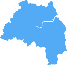
The SR9 postcode area is located in the Sunderland postcode town region, within the county of Tyne and Wear, and contains a total of 25 individual postcodes.
There are -1 electoral wards in the SR9 postcode area, including which come under the local authority of the Sunderland Council.
Combining the whole postcode region, 10% of people in SR9 are classed as having an AB social grade, (i.e. 'white-collar' middle-upper class), compared to 27% across the UK.
This does not mean that the people of SR9 are poorer than other areas, but it may give an indication that there are areas of deprivation.
SR9 is a postcode district in the Sunderland district in the north-east of England. It is centered around the town of Washington, which is located just to the north of Sunderland city itself. The district covers a total area of around 64 square kilometres and is made up of two post towns � Washington and Houghton-le-Spring.
The district is mainly rural, with the majority of its land consisting of farmland and woodlands. The area is home to a number of small villages such as Springwell, North Biddick, Little Rainton, Harraton and Fatfield. There are some larger towns within this postcode district such as Shiney Row, Birtley and Usworth.
The population of this district is around 22,507 people. It is mainly white British with a smaller minority of other ethnicities. The average age in the district is 37 years old.
The SR9 postcode district is home to a range of educational establishments such as secondary schools, sixth form colleges and special needs schools. Washington School, Usworth Grange Primary School and Harraton Community College are based in the district. There are also a range of further education, higher education and adult education establishments too.
The area is well connected to the rest of the UK and the rest of Sunderland with frequent bus and rail services. It is also close to some major roads such as the A19, A1231 and A1290.
SR9 is a great place to explore for its stunning countryside, quaint villages and vibrant towns and cities. It is a great place to live due to its affordability, good transport links and great educational facilities. The area, and Sunderland district in general, is a great place to visit for its rich culture, heritage and many local attractions.

Demographics

Tyne and Wear
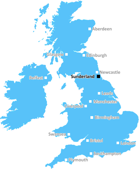
SR9 is located in the county of Tyne and Wear, in England.
Tyne and Wear has a total population of 1,128,800, making it the 16th largest county in the UK.
Tyne and Wear has a total area of 210 square miles, and a population density of 2090 people per square kilometre. For comparison, Greater London has a density of 5,618 people/km2.
| Outward Code | SR9 |
| Postal Town | Sunderland |
| MSOA Name | Sunderland 016 |
| LSOA Name | Sunderland 016C |
| County | Tyne and Wear |
| Region | Tyne and Wear |
| Country | England |
| Local Authority | Sunderland |
| Area Classification | Urban with Major Conurbation |
SR9 Electoral Wards
The postal region of SR9, includes the local towns, villages, electoral wards and stations of:
Dig even deeper into the SR9 postcode by clicking on a postcode below:
Click on an outward postal code below for more information about the area. Each 'outward' postcode give you a comprehensive list of all postcodes within the outward code area (SR) and estimated address.
Click on an 'outward' code for more information. For example, the outward postcode page 'EC2M' will give you an alphabetical list covering all postcodes located in the region, from 'EC2M 1BB' through to 'EC2M 7YA'.
Chris H
Friday, April 12, 2024
We don't have any views of SR9 right now. If you live in SR9 or have visited it, please help us to help others by telling others what you think of this neighbourhood.
Add your view of SR9
People need your local expertise. If you live in SR9 or have first-hand knowledge of the neighbourhood, please consider sharing your views. It's completely anonymous - all we ask is for your initials.
Please tell us what you like about the SR9 postcode area, what you don't like, and what it's like to live or work here.
| LOCAL AMENITIES | |
| FAMILY FRIENDLY | |
| PARKING | |
| GREEN SPACES |
Local News County Durham
Boy, 14, threatened with knife and robbed in Middlesbrough
An appeal has been launched after a teenager was reportedly robbed at knifepoint and had his bike stolen in Normanby, Middlesbrough
Northern EchoDarlington Building Society signs Age-friendly Employer Pledge
Darlington Building Society has signed the Age-friendly Employer Pledge, a nationwide programme launched by the Centre for Ageing Better to improve the recruitment, retention and development of older &hellip
Northern EchoOne arrested after alleged Witton Park Stockton assault
One man has been arrested following an alleged assault on Witton Park in Stockton last month.
Northern EchoConcerns over 'reintroduction' of Lynx to Northumberland
Councillors have spoken of their opposition to the potential reintroduction of lynx to the county.
Northern EchoHays Travel to host holiday and cruise show in Sunderland
Hays Travel are set to host a holiday and cruise show at the Stadium of Light offering customers advice and the newest destinations
Northern EchoDrunken Hartlepool thug attacked partner during TV row
A drunken Hartlepool thug who punched his partner to the ground before strangling her following row over the television has been locked up.
Northern EchoUK Docks wins 250m deal for Royal Navy vessel support
NORTH EAST-based UK Docks has officially taken over the worldwide support of five Royal Navy River Class offshore patrol vessels.
Northern EchoJurors watched footage of murder of Hartlepool pensioner
Jurors have watched the harrowing moment a Hartlepool pensioner was stabbed to death by an 'Islamic fundamentalist' angered by the Gaza conflict.
Northern EchoFrom the Postcode Area blog

Deciphering Crime Rates - a Deep Dive Into UK Postcode Analysis
Ever wondered about the crime rate in your UK postcode? You're not alone. We've dug deep into the data, uncovering trends and patterns that'll make your head spin.

Death of the High Street?
The BBC reports that despite councils' attempts to kurb them, the UK's high streets have seen a huge growth in fast food outlets. Could this mark the death knell for the Great British high street, and what can we do about it to halt its decline?

Discrimination by Postcode
You really couldn't make it up, could you? Some of the country's most vulnerable people are missing out on their weekly £25 Cold Weather Payment, just because the system that's in operation is discriminating against them because payments are based on postcode, rather than geographic location.

The Redesign is Underway
Well, the current website was absolutely in dire need of a good redesign - from the ground up. So I set out to pull it all apart and get it up and running again to become the most comprehensive guide to every postcode in the UK. And it's been a long, tough job from start to finish - and quite possibly the biggest project I've ever undertaken.
SOCIAL GRADES
According to census records, 10% of people here have a social grade of AB (highest), compared to the national average of 27%.