sunderland SR2 Postcodes
Spending a fortune on conveyancing?

Compare instant, low-cost online quotes from trusted conveyancing solicitors.
Backed by experts, our no-obligation service searches through the best conveyancing quotes on the market to save you time and money.
Sunderland (SR2)
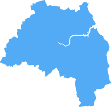
The SR2 postcode area is located in the Sunderland postcode town region, within the county of Tyne and Wear, and contains a total of 1034 individual postcodes.
There are 10 electoral wards in the SR2 postcode area, including Peterlee, Seaham, Sunderland which come under the local authority of the Sunderland Council.
Combining the whole postcode region, 16% of people in SR2 are classed as having an AB social grade, (i.e. 'white-collar' middle-upper class), compared to 27% across the UK.
This does not mean that the people of SR2 are poorer than other areas, but it may give an indication that there are areas of deprivation.
SR2 is a postcode district both covering a large part of the City of Sunderland and small parts of the City of Durham and the Borough of Gateshead in North East England. It has a population of over 77,000.
The postcode district includes most of the city centre recorded in the John Speed map of 1610, as well as areas to the west, south and north of the city centre including Hendon, Millfield, Silksworth, Barnes, South Hylton, St Peter's, Roker, Castletown, Town End Farm, Plains Farm, Ryhope, Whitburn, Seaburn, East Herrington and Houghton-Le-Spring.
SR2 postcode district is located mostly in the City of Sunderland local government district, with a small part covering the City of Durham and a tiny part lying within the Borough of Gateshead. In 2016, SR2 had a population of 73,336. There are 24,535 households in the district with an average household size of 2.9 people.
The main residential areas of SR2 postcode district are Hendon, Roker, Seaburn, East Herrington, Town End Farm, Millfield, Silksworth, Castletown, Houghton-Le-Spring, Rainton Bridge, Plains Farm and Whitburn. There are lots of business areas and shopping areas, such as The Bridges Shopping Centre, Park Lane Centre and Metro Centres, as well as a large industrial estate in the form of the North East Industrial Estate.
SR2 postcode district is served by several transport links such as a number of bus services operated by Go North East and Arriva including the 22, 31, 34, 37, 48 and 98. The postcode district provides excellent road links with the A1231 Sunderland highway providing easy access to other parts of the North East. The nearest railway stations in the area are Sunderland, Seaburn and East Herrington.
SR2 postcode district is a predominantly residential area with a few commercial and industrial areas. It is easy to get around the area using public transport and has a good selection of shops and amenities. It has a diverse population with a wide range of nationalities and is relatively affordable in terms of housing and living costs.

Demographics

Tyne and Wear
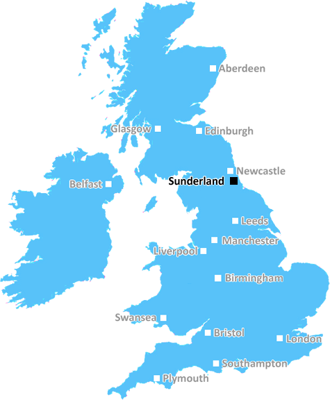
SR2 is located in the county of Tyne and Wear, in England.
Tyne and Wear has a total population of 1,128,800, making it the 16th largest county in the UK.
Tyne and Wear has a total area of 210 square miles, and a population density of 2090 people per square kilometre. For comparison, Greater London has a density of 5,618 people/km2.
| Outward Code | SR2 |
| Postal Town | Sunderland |
| MSOA Name | Sunderland 028 |
| LSOA Name | Sunderland 028C |
| County | Tyne and Wear |
| Region | Tyne and Wear |
| Country | England |
| Local Authority | Sunderland |
| Area Classification | Urban with Major Conurbation |
SR2 Electoral Wards
The postal region of SR2, includes the local towns, villages, electoral wards and stations of:
Dig even deeper into the SR2 postcode by clicking on a postcode below:
Click on an outward postal code below for more information about the area. Each 'outward' postcode give you a comprehensive list of all postcodes within the outward code area (SR) and estimated address.
Click on an 'outward' code for more information. For example, the outward postcode page 'EC2M' will give you an alphabetical list covering all postcodes located in the region, from 'EC2M 1BB' through to 'EC2M 7YA'.
Chris H
Sunday, April 7, 2024
We don't have any views of SR2 right now. If you live in SR2 or have visited it, please help us to help others by telling others what you think of this neighbourhood.
Add your view of SR2
People need your local expertise. If you live in SR2 or have first-hand knowledge of the neighbourhood, please consider sharing your views. It's completely anonymous - all we ask is for your initials.
Please tell us what you like about the SR2 postcode area, what you don't like, and what it's like to live or work here.
| LOCAL AMENITIES | |
| FAMILY FRIENDLY | |
| PARKING | |
| GREEN SPACES |
Local News County Durham
Men jailed after burglary at home of Middlesbrough pensioner
Kirk Scotland, 39, and Brian Crutchley, 33, barged into the property in Middlesbrough town centre onSeptember 17, 2023.
Northern EchoGarden gnomes help to support Darlington man with brain cancer
A garden full of gnomes has delighted visitors to a NorthYorkshire village - while raising awareness of a fundraising campaign for a man with terminal cancer.
Northern EchoCounty Durham sporting sisters competing at national level
County Durham sporting sisters Phoebe and Mae Arnott are competing at national level in their sports.
Northern EchoCleveland Police pay XL Bully owner 4,000 after court case
A Cleveland Police spokesperson said: Cleveland Police made an application for a destruction order on the dog, due to an attack on a child.
Northern EchoObjections lodged against 27 Bolton Crofts Richmond houses
Campaigners against the site, which is located at Bolton Avenue, near Richmond, believe that the building of the houses would be 'disastrous'.
Northern EchoScott Bros concrete facility on site of 6m plant in Thornaby
Recycling specialists Scott Bros is to install a plant on the site of their 6m wash plant over the next few months that will produce low carbon concrete.
Northern EchoLamb killed in barn fire in Manfield village near Darlington
Emergency services were called to Manfield village at about 11.17pm, following reports of an agricultural fire in a barn containing livestock.
Northern EchoTeesside NHS workers extend strike over pay dispute
More than a thousand Teesside NHS healthcare assistants are set to strike for three more days as disputes over pay continue
Northern EchoFrom the Postcode Area blog

Deciphering Crime Rates - a Deep Dive Into UK Postcode Analysis
Ever wondered about the crime rate in your UK postcode? You're not alone. We've dug deep into the data, uncovering trends and patterns that'll make your head spin.

Death of the High Street?
The BBC reports that despite councils' attempts to kurb them, the UK's high streets have seen a huge growth in fast food outlets. Could this mark the death knell for the Great British high street, and what can we do about it to halt its decline?

Discrimination by Postcode
You really couldn't make it up, could you? Some of the country's most vulnerable people are missing out on their weekly £25 Cold Weather Payment, just because the system that's in operation is discriminating against them because payments are based on postcode, rather than geographic location.

The Redesign is Underway
Well, the current website was absolutely in dire need of a good redesign - from the ground up. So I set out to pull it all apart and get it up and running again to become the most comprehensive guide to every postcode in the UK. And it's been a long, tough job from start to finish - and quite possibly the biggest project I've ever undertaken.
SOCIAL GRADES
According to census records, 16% of people here have a social grade of AB (highest), compared to the national average of 27%.