plymouth PL35 Postcodes
Spending a fortune on conveyancing?

Compare instant, low-cost online quotes from trusted conveyancing solicitors.
Backed by experts, our no-obligation service searches through the best conveyancing quotes on the market to save you time and money.
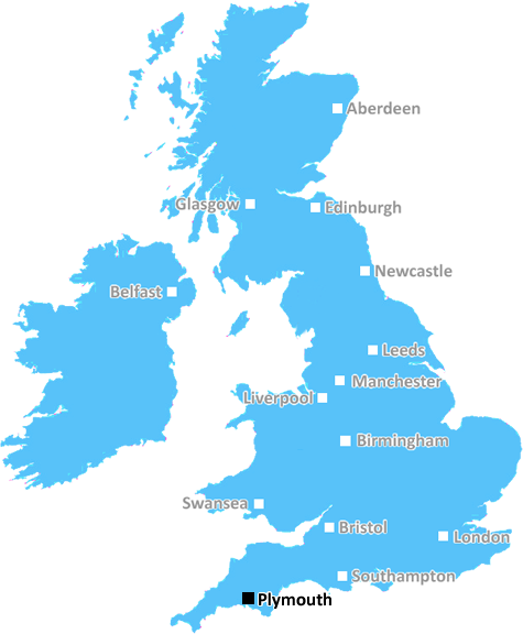
Plymouth (PL35)
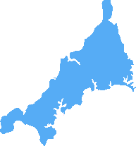
The PL35 postcode area is located in the Plymouth postcode town region, within the county of Cornwall, and contains a total of 87 individual postcodes.
There are 10 electoral wards in the PL35 postcode area, including Bodmin, Boscastle, Callington, Calstock, Camelford, Delabole, Fowey, Gunnislake, Ivybridge, Launceston, Lifton, Liskeard, Looe, Lostwithiel, Padstow, Par, Plymouth, Port Isaac, Saltash, St Austell, Tavistock, Tintagel, Torpoint, Wadebridge, Yelverton which come under the local authority of the Cornwall,Isles of Scilly Council.
Combining the whole postcode region, 21% of people in PL35 are classed as having an AB social grade, (i.e. 'white-collar' middle-upper class), compared to 27% across the UK.
This does not mean that the people of PL35 are poorer than other areas, but it may give an indication that there are areas of deprivation.
The PL35 postcode is located in the Plymouth district, in the county of Devon in the South West of England. It covers the area along the stretch of coastline between Millbay/the Barbican, in the centre of the city, and Staddon, an area to the south.
The area known as Millbay includes an inner harbour, often referred to as Sutton Harbour, which plays an important role in the city's busy fishing industry, and Barne Barton, a disadvantaged area which used to be a military base. The Barbican area includes some of the city's most historic buildings, a number of marinas and some of the best fish and chip restaurants you'll find anywhere. this area of Plymouth has seen a lot of investment over the years in order to help bring it up to its former glory.
Staddon is a residential area, which also includes a golfing centre, the Mount Batten Watersports centre, and the Staddon Heights Nature Reserve � a stunning area of coastline and woodland managed by the National Trust.
The PL35 postcode is very popular with commuters into the city as it is served by the local railway and is close to a number of major road routes, making it easy to get to key locations throughout the South West. The local school is St. Boniface Catholic School which serves both the Millbay and Staddon areas.
this postcode has a lot to offer. Whether it's activities in the fantastic natural surroundings, vibrant bars and restaurants or a commuter's dream, Plymouth is definitely the place to be.

Demographics

Cornwall
PL35 is located in the county of Cornwall, in England.
Cornwall has a total population of 556,000, making it the 40th largest county in the UK.
Cornwall has a total area of 1375 square miles, and a population density of 156 people per square kilometre. For comparison, Greater London has a density of 5,618 people/km2.
| Outward Code | PL35 |
| Postal Town | Plymouth |
| MSOA Name | Cornwall 003 |
| LSOA Name | Cornwall 003D |
| County | Cornwall |
| Region | Cornwall |
| Country | England |
| Local Authority | Cornwall,Isles of Scilly |
| Area Classification | Mainly Rural (rural including hub towns >=80%) |
PL35 Electoral Wards
The postal region of PL35, includes the local towns, villages, electoral wards and stations of:
Dig even deeper into the PL35 postcode by clicking on a postcode below:
Click on an outward postal code below for more information about the area. Each 'outward' postcode give you a comprehensive list of all postcodes within the outward code area (PL) and estimated address.
Click on an 'outward' code for more information. For example, the outward postcode page 'EC2M' will give you an alphabetical list covering all postcodes located in the region, from 'EC2M 1BB' through to 'EC2M 7YA'.
Chris H
Monday, March 25, 2024
We don't have any views of PL35 right now. If you live in PL35 or have visited it, please help us to help others by telling others what you think of this neighbourhood.
Add your view of PL35
People need your local expertise. If you live in PL35 or have first-hand knowledge of the neighbourhood, please consider sharing your views. It's completely anonymous - all we ask is for your initials.
Please tell us what you like about the PL35 postcode area, what you don't like, and what it's like to live or work here.
| LOCAL AMENITIES | |
| FAMILY FRIENDLY | |
| PARKING | |
| GREEN SPACES |
Local News Cornwall
Transformation of services to offer independence
Hundreds of people who use services such as day centres or supported employment gave their views.
BBC NewsFarmers take to the streets in tractors to protests over Brexit
They circled the streets of Cornwall to raise awareness
Cornwall LiveKayaker saved in Cornish sea cave rescue
An RNLI volunteer had to swim into the cave to help the man who was clinging to rocks.
BBC NewsWeekend closure for part of Cornwall's A30
Part of the A30 is closed until Monday for essential drainage and structural work.
BBC NewsStrong winds, rough seas and hail showers cancel ferries from Penzance to Isles of Scilly
The Met Office predicts windspeeds reaching 40mph across the islands, with heavy showers set to hit Cornwall
Cornwall LiveAward-winning converted chapel could be the most unique home in Cornwall
The four-bedroom property is situated in Pendoggett near Port Isaac
Cornwall LiveInteractive map shows every UFO spotted in UK since 2021 including 22 across Cornwall
Interactive map reveals the locations most likely to be visited by aliens
Cornwall LivePilot boat returning to Scotland for tragic reason
She was named after Captain Laurie Mitchell who died in a sea tragedy off Falmouth in 1974
Cornwall LiveFrom the Postcode Area blog

Deciphering Crime Rates - a Deep Dive Into UK Postcode Analysis
Ever wondered about the crime rate in your UK postcode? You're not alone. We've dug deep into the data, uncovering trends and patterns that'll make your head spin.

Death of the High Street?
The BBC reports that despite councils' attempts to kurb them, the UK's high streets have seen a huge growth in fast food outlets. Could this mark the death knell for the Great British high street, and what can we do about it to halt its decline?

Discrimination by Postcode
You really couldn't make it up, could you? Some of the country's most vulnerable people are missing out on their weekly £25 Cold Weather Payment, just because the system that's in operation is discriminating against them because payments are based on postcode, rather than geographic location.

The Redesign is Underway
Well, the current website was absolutely in dire need of a good redesign - from the ground up. So I set out to pull it all apart and get it up and running again to become the most comprehensive guide to every postcode in the UK. And it's been a long, tough job from start to finish - and quite possibly the biggest project I've ever undertaken.
SOCIAL GRADES
According to census records, 21% of people here have a social grade of AB (highest), compared to the national average of 27%.