liverpool L39 Postcodes
Spending a fortune on conveyancing?

Compare instant, low-cost online quotes from trusted conveyancing solicitors.
Backed by experts, our no-obligation service searches through the best conveyancing quotes on the market to save you time and money.
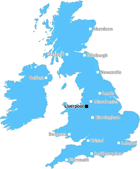
Liverpool (L39)
The L39 postcode area is located in the Liverpool postcode town region, within the county of Lancashire, and contains a total of 1041 individual postcodes.
There are 57 electoral wards in the L39 postcode area, including Bootle, Liverpool, Ormskirk, Prescot which come under the local authority of the West Lancashire Council.
Combining the whole postcode region, 30% of people in L39 are classed as having an AB social grade, (i.e. 'white-collar' middle-upper class), compared to 27% across the UK.
This does not mean that the people of L39 are wealthier - or higher class - than average, but it can be an indication that the area may be prospering and desirable to live in.
The L39 postcode is located in the West Lancashire area of England, in the northwest of the country. It covers a number of small villages and towns, including rural Ormskirk, the larger settlement of Burscough, Bispham and Scarisbrick. The postcode is made up of the two districts of South and North Lancashire and is bordered by the postcodes of L38, L40 and L37.
Ormskirk is the main town in the postcode and holds the Market Square with the historic clock tower from the 13th century. The town also has a selection of shops, restaurants and pubs and is the home of the Independent Ormskirk Advertiser newspaper.
Burscough is an industrial village with a focus on the active lime industry, and a variety of local businesses. One of its main attractions is the award-winning Burscough Bridge, a nine-arched bridge over the river Douglas, built in 1778. The historic Burscough Priory, built in 1227, is also located here.
Bispham is a village with a range of activities for visitors to enjoy, such as the terraced gardens in the local lime quarries. Bordering the town is Scarisbrick, a quiet village with a golf course, cricket club and local church.
The L39 postcode hosts a range of urban facilities, such as leisure centres and libraries, with shops and supermarkets located in Ormskirk and Burscough. There are also several primary and secondary schools situated within the postcode's boundary, including Ormskirk's Edge Hill University.
The postcode is well-connected to nearby towns and cities by road, rail and bus links, with regular rail services to Liverpool, Southport and Wigan, and a number of bus routes linking Ormskirk to other destinations. There is also easy access to both of the UK's major airports, Manchester and Liverpool.
The postcode is a part of the West Lancashire Borough Council, with the divisional town hall located in Ormskirk. The council covers a range of local services, from environmental health to leisure and culture, and each district within the postcode has its own local council representation.
In terms of outdoor activities, the postcode has a variety of parks and nature reserves, including Ormskirk's Coronation Park, Tawd Valley Park in Skelmesdale, and Simonswood Nature Reserve. There are also a number of golf courses, walking trails and cycle paths across the area.
The postcode is a rural area and is made up of a mix of centuries-old settlements, smaller villages and modern towns. It is home to a range of local attractions, leisure venues and outdoor activities, and is well-connected to nearby destinations by road and rail.

Demographics

Lancashire

L39 is located in the county of Lancashire, in England.
Lancashire has a total population of 1,485,000, making it the 8th largest county in the UK.
Lancashire has a total area of 1187 square miles, and a population density of 482 people per square kilometre. For comparison, Greater London has a density of 5,618 people/km2.
| Outward Code | L39 |
| Postal Town | Liverpool |
| MSOA Name | West Lancashire 008 |
| LSOA Name | West Lancashire 008A |
| County | Lancashire |
| Region | Lancashire |
| Country | England |
| Local Authority | West Lancashire |
| Area Classification | Urban with Significant Rural (rural including hub towns 26-49%) |
L39 Electoral Wards
The postal region of L39, includes the local towns, villages, electoral wards and stations of:
Dig even deeper into the L39 postcode by clicking on a postcode below:
Click on an outward postal code below for more information about the area. Each 'outward' postcode give you a comprehensive list of all postcodes within the outward code area (L) and estimated address.
Click on an 'outward' code for more information. For example, the outward postcode page 'EC2M' will give you an alphabetical list covering all postcodes located in the region, from 'EC2M 1BB' through to 'EC2M 7YA'.
MJ, Liverpool
Sunday, October 24, 2021
One street light , speed limit reaching 60mph past the house, have to walk a Mile to catch a Bus, No shops , Always forgotten when it comes to Updating Kitchens Bathrooms , but there again Post code does not show up on List . L39 8RX
Add your view of L39
People need your local expertise. If you live in L39 or have first-hand knowledge of the neighbourhood, please consider sharing your views. It's completely anonymous - all we ask is for your initials.
Please tell us what you like about the L39 postcode area, what you don't like, and what it's like to live or work here.
| LOCAL AMENITIES | |
| FAMILY FRIENDLY | |
| PARKING | |
| GREEN SPACES |
Local News Lancashire
Surrey only face 21 balls on rain-affected day
Openers Rory Burns and Dom Sibley are only able to add four runs as rain ruins Surrey's reply to Lancashire's 202.
BBC NewsFull steam ahead for historic mill after repairs
"Steam Sunday" at Bancroft Mill was delayed by problems with the 112-year-old boiler.
BBC NewsMan arrested after mosque break-in
A man ran away after he was challenged by some men already inside the building, police say.
BBC NewsMore children and young people getting MMR jab
Health bosses have warned measles 'hasn't gone away', urging people to ensure they are protected.
BBC NewsBoy held after police officer struck by stolen car
A stolen mobility car was "deliberately driven" at an officer as he approached it, police say.
BBC NewsBlackpool 1-0 Cambridge United
Blackpool keep their faint League One play-off hopes alive with a narrow win over Cambridge at Bloomfield Road.
BBC NewsWatford and Preston play out goalless draw
Watford and Preston play out a relatively drab goalless draw in the Championship.
BBC NewsEverton beat Burnley to boost survival hopes
Dominic Calvert-Lewin capitalises on an Arijanet Muric error to score his second goal in as many games and help Everton to a priceless win over fellow strugglers Burnley.
BBC NewsFrom the Postcode Area blog

Deciphering Crime Rates - a Deep Dive Into UK Postcode Analysis
Ever wondered about the crime rate in your UK postcode? You're not alone. We've dug deep into the data, uncovering trends and patterns that'll make your head spin.

Death of the High Street?
The BBC reports that despite councils' attempts to kurb them, the UK's high streets have seen a huge growth in fast food outlets. Could this mark the death knell for the Great British high street, and what can we do about it to halt its decline?

Discrimination by Postcode
You really couldn't make it up, could you? Some of the country's most vulnerable people are missing out on their weekly £25 Cold Weather Payment, just because the system that's in operation is discriminating against them because payments are based on postcode, rather than geographic location.

The Redesign is Underway
Well, the current website was absolutely in dire need of a good redesign - from the ground up. So I set out to pull it all apart and get it up and running again to become the most comprehensive guide to every postcode in the UK. And it's been a long, tough job from start to finish - and quite possibly the biggest project I've ever undertaken.
SOCIAL GRADES
According to census records, 30% of people here have a social grade of AB (highest), compared to the national average of 27%.