durham DH4 Postcodes
Spending a fortune on conveyancing?

Compare instant, low-cost online quotes from trusted conveyancing solicitors.
Backed by experts, our no-obligation service searches through the best conveyancing quotes on the market to save you time and money.
Durham (DH4)
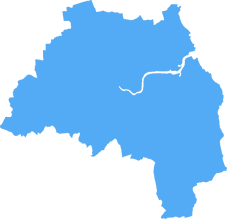
The DH4 postcode area is located in the Durham postcode town region, within the county of Tyne and Wear, and contains a total of 1108 individual postcodes.
There are 36 electoral wards in the DH4 postcode area, including Chester Le Street, Consett, Durham, Houghton Le Spring, Stanley which come under the local authority of the Sunderland Council.
Combining the whole postcode region, 16% of people in DH4 are classed as having an AB social grade, (i.e. 'white-collar' middle-upper class), compared to 27% across the UK.
This does not mean that the people of DH4 are poorer than other areas, but it may give an indication that there are areas of deprivation.
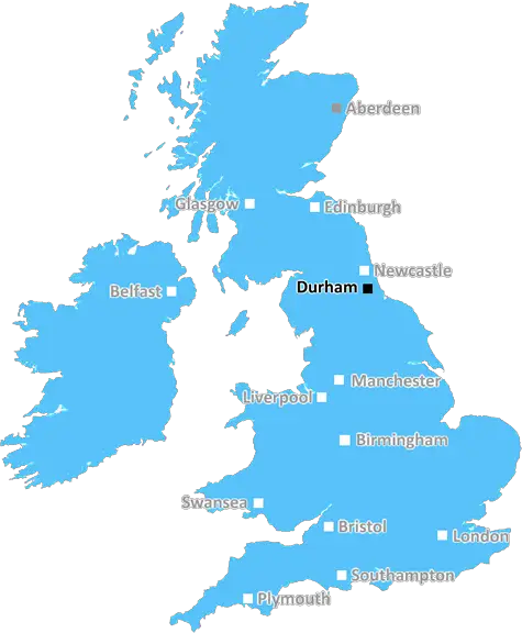
The DH4 postcode identifies the district of Houghton-le-Spring located in County Durham. It is a north-eastern English post town consisting of roughly 12,000 households within its area.
Situated 8 miles south from Sunderland and 13 miles north-east of Durham City, the postcode includes the nearby towns of Hetton-le-Hole, Easington Lane, Haswell, Lumley, East Rainton and more.
The DH4 postcode has a diverse population with people from all backgrounds, cultures and beliefs living in the area. The population is made up of 30% over the age of 45 and with an average age of 41. The region is a very diverse one in terms of ethnicities, with a range of Iranian, Pakistani, Indian and central European backgrounds.
For those interested in history, the region is home to some of the most spectacular historical landmarks in the area � including churches, workshops, and schools dating back hundreds of years. This is not to mention the numerous towns and villages nearby, including the ancient market town of Hetton-le-Hole.
Education-wise, the DH4 postcode is home to Houghton Kepier Academy, a secondary school which has been award-winning for its teaching and curriculum. It is also host to two further education colleges � East Durham College, Durham Sixth Form Centre and also The Linehaul Centre.
The area offers a range of leisure and recreational activities, with its various cycling paths, sports complexes and a number of public parks. There are a range of pubs, restaurants and cafe's for visitors, as well as a local market for groceries.
The DH4 postcode also has one of the most creative arts scenes in the region. With films, plays, music nights and art exhibitions, the postcode has something for everyone. There are also a handful of creative business centres, offering opportunities to start-ups and entrepreneurs.
All in all, there's no shortage of things to do for the people of the DH4 postcode, and its inhabitants would be proud to call Houghton-le-Spring home.

Demographics

Tyne and Wear
DH4 is located in the county of Tyne and Wear, in England.
Tyne and Wear has a total population of 1,128,800, making it the 16th largest county in the UK.
Tyne and Wear has a total area of 210 square miles, and a population density of 2090 people per square kilometre. For comparison, Greater London has a density of 5,618 people/km2.
| Outward Code | DH4 |
| Postal Town | Durham |
| MSOA Name | Sunderland 034 |
| LSOA Name | Sunderland 034F |
| County | Tyne and Wear |
| Region | Tyne and Wear |
| Country | England |
| Local Authority | Sunderland |
| Area Classification | Urban with Major Conurbation |
DH4 Electoral Wards
The postal region of DH4, includes the local towns, villages, electoral wards and stations of:
Dig even deeper into the DH4 postcode by clicking on a postcode below:
Click on an outward postal code below for more information about the area. Each 'outward' postcode give you a comprehensive list of all postcodes within the outward code area (DH) and estimated address.
Click on an 'outward' code for more information. For example, the outward postcode page 'EC2M' will give you an alphabetical list covering all postcodes located in the region, from 'EC2M 1BB' through to 'EC2M 7YA'.
Chris H
Thursday, April 11, 2024
We don't have any views of DH4 right now. If you live in DH4 or have visited it, please help us to help others by telling others what you think of this neighbourhood.
Add your view of DH4
People need your local expertise. If you live in DH4 or have first-hand knowledge of the neighbourhood, please consider sharing your views. It's completely anonymous - all we ask is for your initials.
Please tell us what you like about the DH4 postcode area, what you don't like, and what it's like to live or work here.
| LOCAL AMENITIES | |
| FAMILY FRIENDLY | |
| PARKING | |
| GREEN SPACES |
Local News County Durham
Lightbulb, charger and fridge safety warning issued to UK homes
Safety officer, Gary Johnstone from Pleavin Power has issued a home electrical safety warning to British households.
Northern EchoA689 Incident LIVE: road reopens after crash sees one in hospital
The A689 has now reopened after a one vehicle collision saw one person taken to hospital, earlier today.
Northern EchoLabour's plan to resurrect high streets across North East
The Labour Party has promised a resurrection of high streets across the North East after they set out a five-point plan.
Northern EchoFirefighters attend St Peter's Church, Bishop Auckland fire
Emergency services attended a fire at St Peter's Church in Bishop Auckland this evening
Northern EchoA Middlesbrough arsonist targeted Cleveland Police station
A Middlesbrough arsonist who tried to firebomb a police station has been locked up after he was recognised from CCTV footage.
Northern EchoDWP Universal Credit and PIP warning to anyone going abroad
PIP and Universal Credit claimants must inform the Department for Work and Pensions (DWP) if they are planning to travel abroad this summer
Northern EchoHarrogate area gang jailed for robbery and gun plot
Four men involved in a robbery and firearms plot in North Yorkshire have been jailed.
Northern EchoHS2 funds reallocated to repair Durham & Darlington roads
Funds from HS2 have been reallocated to maintain roads across the country - here's where they will be used in County Durham and Darlington.
Northern EchoFrom the Postcode Area blog

Deciphering Crime Rates - a Deep Dive Into UK Postcode Analysis
Ever wondered about the crime rate in your UK postcode? You're not alone. We've dug deep into the data, uncovering trends and patterns that'll make your head spin.

Death of the High Street?
The BBC reports that despite councils' attempts to kurb them, the UK's high streets have seen a huge growth in fast food outlets. Could this mark the death knell for the Great British high street, and what can we do about it to halt its decline?

Discrimination by Postcode
You really couldn't make it up, could you? Some of the country's most vulnerable people are missing out on their weekly £25 Cold Weather Payment, just because the system that's in operation is discriminating against them because payments are based on postcode, rather than geographic location.

The Redesign is Underway
Well, the current website was absolutely in dire need of a good redesign - from the ground up. So I set out to pull it all apart and get it up and running again to become the most comprehensive guide to every postcode in the UK. And it's been a long, tough job from start to finish - and quite possibly the biggest project I've ever undertaken.
SOCIAL GRADES
According to census records, 16% of people here have a social grade of AB (highest), compared to the national average of 27%.