bath BA13 Postcodes
Spending a fortune on conveyancing?

Compare instant, low-cost online quotes from trusted conveyancing solicitors.
Backed by experts, our no-obligation service searches through the best conveyancing quotes on the market to save you time and money.
Bath (BA13)
The BA13 postcode area is located in the Bath postcode town region, within the county of Wiltshire, and contains a total of 743 individual postcodes.
There are 37 electoral wards in the BA13 postcode area, including Bath, Bradford-On-Avon, Bruton, Castle Cary, Frome, Glastonbury, Radstock, Shepton Mallet, Street, Templecombe, Trowbridge, Warminster, Wells, Westbury, Wincanton, Yeovil which come under the local authority of the Wiltshire Council.
Combining the whole postcode region, 24% of people in BA13 are classed as having an AB social grade, (i.e. 'white-collar' middle-upper class), compared to 27% across the UK.
This does not mean that the people of BA13 are poorer than other areas, but it may give an indication that there are areas of deprivation.
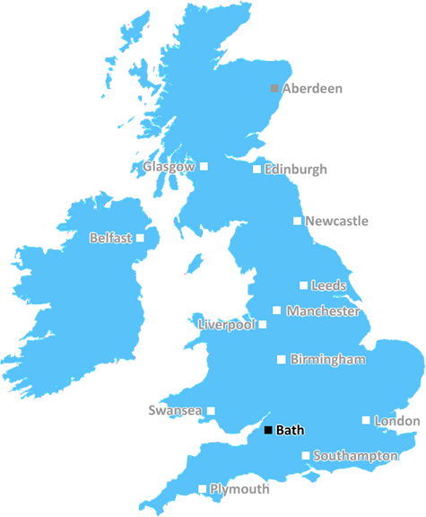
The BA13 postcode in the Bath district in UK is a postcode area that covers the eastern parts of Wiltshire, and includes the market town of Westbury and the village of Ashley. It also covers the Avon towns of Warminster and Frome.
The postcode covers the area surrounding the historically important and picturesque city of Bath, the World Heritage Site, and its suburbs of Southdown, Hest Platt, Cheverell, Bratton, Frome and Edington.
The postcode is known for its excellent transport links to Bath, including the A36, A364 and A350. This makes it easily accessible to the city, and gives access to all forms of transport in the area, as well as allowing easy exploration of other regions of Wiltshire.
The area is served by two main railway stations, Westbury and Frome. It is also on the main bus routes from Bath to Warminster, Frome and Westbury.
The postcode is conveniently situated close to two of Wiltshire's largest towns, Trowbridge and Chippenham and has a wide range of leisure and recreational facilities, from hot air balloon rides, to cycle routes and horse riding centres.
The area has a high population density, with around 30,000 people living in the postcode area. The area lies between the Mendip Hills and Salisbury Plain and is known for its beautiful landscape, with rolling hills, thriving woods and local wildlife.
The area is also home to two great visitor attractions, Longleat Safari Park and Stonehenge, helping to attract visitors from all over the world.
TheBA13 postcode is an attractive and hugely popular area of Wiltshire, with its excellent transport links, attractive landscape and plenty of leisure and recreational activities to explore. It is a great place to live, work and visit.

Demographics
Wiltshire

BA13 is located in the county of Wiltshire, in England.
Wiltshire has a total population of 706,300, making it the 34th largest county in the UK.
Wiltshire has a total area of 1346 square miles, and a population density of 202 people per square kilometre. For comparison, Greater London has a density of 5,618 people/km2.
| Outward Code | BA13 |
| Postal Town | Bath |
| MSOA Name | Wiltshire 040 |
| LSOA Name | Wiltshire 040C |
| County | Wiltshire |
| Region | Wiltshire |
| Country | England |
| Local Authority | Wiltshire |
| Area Classification | Largely Rural (rural including hub towns 50-79%) |
BA13 Electoral Wards
The postal region of BA13, includes the local towns, villages, electoral wards and stations of:
Dig even deeper into the BA13 postcode by clicking on a postcode below:
Click on an outward postal code below for more information about the area. Each 'outward' postcode give you a comprehensive list of all postcodes within the outward code area (BA) and estimated address.
Click on an 'outward' code for more information. For example, the outward postcode page 'EC2M' will give you an alphabetical list covering all postcodes located in the region, from 'EC2M 1BB' through to 'EC2M 7YA'.
Chris H
Tuesday, April 9, 2024
We don't have any views of BA13 right now. If you live in BA13 or have visited it, please help us to help others by telling others what you think of this neighbourhood.
Add your view of BA13
People need your local expertise. If you live in BA13 or have first-hand knowledge of the neighbourhood, please consider sharing your views. It's completely anonymous - all we ask is for your initials.
Please tell us what you like about the BA13 postcode area, what you don't like, and what it's like to live or work here.
| LOCAL AMENITIES | |
| FAMILY FRIENDLY | |
| PARKING | |
| GREEN SPACES |
Local News Wiltshire
County awarded 375k for walking and cycling schemes
The local authority say the plans will help to improve air quality and decarbonisation in the county.
BBC NewsRescue volunteers to take on overseas challenge
Volunteers prepare to fly out to Kosovo for a gruelling five-day exercise before they qualify.
BBC NewsVacant retirement home to be replaced by 17 houses
Aster Communities is given permission for the scheme as part of the county's development plan.
BBC NewsBarrow 0-2 Swindon Town
Paul Glatzel continues his fine recent goalscoring form as Swindon stun League Two promotion-chasers Barrow with a 2-0 victory.
BBC NewsExhibition with photo from Led Zeppelin album opens
The original Victorian photograph behind the album artwork of Led Zeppelin IV goes on display.
BBC NewsWiltshire PCC election: What you need to know
Four candidates are standing for election for the role of Police and Crime Commissioner on 2 May.
BBC NewsAfrican wild dogs settling in 'fantastically'
The pack of six brothers have been brought to Longleat Safari Park as part of conservation efforts.
BBC NewsCity gyratory route set to close for roadworks
The closure will affect inbound and outbound traffic to and from Salisbury for three nights.
BBC NewsFrom the Postcode Area blog

Deciphering Crime Rates - a Deep Dive Into UK Postcode Analysis
Ever wondered about the crime rate in your UK postcode? You're not alone. We've dug deep into the data, uncovering trends and patterns that'll make your head spin.

Death of the High Street?
The BBC reports that despite councils' attempts to kurb them, the UK's high streets have seen a huge growth in fast food outlets. Could this mark the death knell for the Great British high street, and what can we do about it to halt its decline?

Discrimination by Postcode
You really couldn't make it up, could you? Some of the country's most vulnerable people are missing out on their weekly £25 Cold Weather Payment, just because the system that's in operation is discriminating against them because payments are based on postcode, rather than geographic location.

The Redesign is Underway
Well, the current website was absolutely in dire need of a good redesign - from the ground up. So I set out to pull it all apart and get it up and running again to become the most comprehensive guide to every postcode in the UK. And it's been a long, tough job from start to finish - and quite possibly the biggest project I've ever undertaken.
SOCIAL GRADES
According to census records, 24% of people here have a social grade of AB (highest), compared to the national average of 27%.