warrington WA12 Postcodes
Spending a fortune on conveyancing?

Compare instant, low-cost online quotes from trusted conveyancing solicitors.
Backed by experts, our no-obligation service searches through the best conveyancing quotes on the market to save you time and money.
Warrington (WA12)
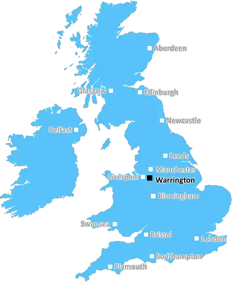
The WA12 postcode area is located in the Warrington postcode town region, within the county of Merseyside, and contains a total of 832 individual postcodes.
There are 13 electoral wards in the WA12 postcode area, including Altrincham, Frodsham, Knutsford, Lymm, Newton-Le-Willows, Runcorn, St Helens, Warrington, Widnes which come under the local authority of the St. Helens Council.
Combining the whole postcode region, 17% of people in WA12 are classed as having an AB social grade, (i.e. 'white-collar' middle-upper class), compared to 27% across the UK.
This does not mean that the people of WA12 are poorer than other areas, but it may give an indication that there are areas of deprivation.
The WA12 postcode in the Warrington district is home to several neighbourhoods including Orford, Warrington Bank Quay, Westbrook, and Padgate. Situated in the north west of Warrington, WA12 has strong connections to the Manchester and Merseyside areas but still offers plenty of amenities within the district itself.
One of the main attractions to Orford is the Orford Jubilee Park which opened in 1975 and is home to an outdoor amphitheatre, various sports pitches, and a children's play area. Not far away from Orford is Warrington Bank Quay, which is home to the Bank Quay railway station. It offers convenient transportation links with trains travelling to major nearby cities such as Liverpool and Manchester.
Further down the postcode district you find Westbrook which is home to a large retail park, including the Golden Square Shopping Centre. The centre offers a wide range of shops and services, as well as regular entertainment events throughout the year. Other shops within the district include a B&M Home Store, a Currys PC World, and a Greggs. Also located within Westbrook is Westbrook Primary School, which has a strong track record of successful students and is popular with the local community.
The last neighbourhood in the postcode district is Padgate which is home to some historic buildings, however many of the shops located in Padgate have closed in recent years. There are still various services which can be found in the area, such as small grocers and a leisure centre as well as some takeaways. The University of Chester also has an office located within Padgate.
WA12 postcode district in Warrington has plenty of attractions to offer, ranging from pleasant parks and shopping centres to historic sites and educational establishments. The area boasts good transport links to nearby cities and is home to various small shops and businesses, offering convenience to locals and visitors alike.

Demographics

Merseyside

WA12 is located in the county of Merseyside, in England.
Merseyside has a total population of 1,406,400, making it the 9th largest county in the UK.
Merseyside has a total area of 250 square miles, and a population density of 2174 people per square kilometre. For comparison, Greater London has a density of 5,618 people/km2.
| Outward Code | WA12 |
| Postal Town | Warrington |
| MSOA Name | St. Helens 015 |
| LSOA Name | St. Helens 015D |
| County | Merseyside |
| Region | Merseyside |
| Country | England |
| Local Authority | St. Helens |
| Area Classification | Urban with Major Conurbation |
WA12 Electoral Wards
The postal region of WA12, includes the local towns, villages, electoral wards and stations of:
Dig even deeper into the WA12 postcode by clicking on a postcode below:
Click on an outward postal code below for more information about the area. Each 'outward' postcode give you a comprehensive list of all postcodes within the outward code area (WA) and estimated address.
Click on an 'outward' code for more information. For example, the outward postcode page 'EC2M' will give you an alphabetical list covering all postcodes located in the region, from 'EC2M 1BB' through to 'EC2M 7YA'.
Chris H
Sunday, April 7, 2024
We don't have any views of WA12 right now. If you live in WA12 or have visited it, please help us to help others by telling others what you think of this neighbourhood.
Add your view of WA12
People need your local expertise. If you live in WA12 or have first-hand knowledge of the neighbourhood, please consider sharing your views. It's completely anonymous - all we ask is for your initials.
Please tell us what you like about the WA12 postcode area, what you don't like, and what it's like to live or work here.
| LOCAL AMENITIES | |
| FAMILY FRIENDLY | |
| PARKING | |
| GREEN SPACES |
Local News Lancashire
Blackpool 1-0 Cambridge United
Blackpool keep their faint League One play-off hopes alive with a narrow win over Cambridge at Bloomfield Road.
BBC NewsMan arrested after mosque break-in
A man ran away after he was challenged by some men already inside the building, police say.
BBC NewsSteel takes 5-25 as Surrey bowl out Lancashire
Defending champions Surrey dismiss Lancashire for 202 as Cam Steel and Dan Lawrence both return career-best bowling figures.
BBC News'Arranged' gang fight causes distress for residents
Police in Burnley and Rawtenstall town centres were tackling reports of a "pre-arranged fight".
BBC NewsWhere in the UK can you see Monday's solar eclipse?
People in the UK can also see the solar eclipse happening in the US next week
BBC NewsVolunteer groups at 'crisis point' over NHS referrals
Organisations in Lancashire say they are under pressure due to a rapid increase in "social prescribing".
BBC NewsEverton beat Burnley to boost survival hopes
Dominic Calvert-Lewin capitalises on an Arijanet Muric error to score his second goal in as many games and help Everton to a priceless win over fellow strugglers Burnley.
BBC NewsG4 superfan changes her name in honour of singers
Christine Christie Ansell Duncan Jai Martin changed her name in tribute to the X Factor finalists.
BBC NewsFrom the Postcode Area blog

Deciphering Crime Rates - a Deep Dive Into UK Postcode Analysis
Ever wondered about the crime rate in your UK postcode? You're not alone. We've dug deep into the data, uncovering trends and patterns that'll make your head spin.

Death of the High Street?
The BBC reports that despite councils' attempts to kurb them, the UK's high streets have seen a huge growth in fast food outlets. Could this mark the death knell for the Great British high street, and what can we do about it to halt its decline?

Discrimination by Postcode
You really couldn't make it up, could you? Some of the country's most vulnerable people are missing out on their weekly £25 Cold Weather Payment, just because the system that's in operation is discriminating against them because payments are based on postcode, rather than geographic location.

The Redesign is Underway
Well, the current website was absolutely in dire need of a good redesign - from the ground up. So I set out to pull it all apart and get it up and running again to become the most comprehensive guide to every postcode in the UK. And it's been a long, tough job from start to finish - and quite possibly the biggest project I've ever undertaken.
SOCIAL GRADES
According to census records, 17% of people here have a social grade of AB (highest), compared to the national average of 27%.