truro TR4 Postcodes
Spending a fortune on conveyancing?

Compare instant, low-cost online quotes from trusted conveyancing solicitors.
Backed by experts, our no-obligation service searches through the best conveyancing quotes on the market to save you time and money.
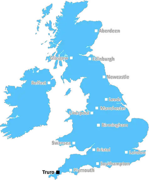
Truro (TR4)
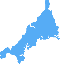
The TR4 postcode area is located in the Truro postcode town region, within the county of Cornwall, and contains a total of 556 individual postcodes.
There are 131 electoral wards in the TR4 postcode area, including Camborne, Falmouth, Hayle, Helston, Isles Of Scilly, Marazion, Newquay, Penryn, Penzance, Perranporth, Redruth, St Agnes, St Columb, St Ives, Truro which come under the local authority of the Cornwall,Isles of Scilly Council.
Combining the whole postcode region, 27% of people in TR4 are classed as having an AB social grade, (i.e. 'white-collar' middle-upper class), compared to 27% across the UK.
This does not mean that the people of TR4 are poorer than other areas, but it may give an indication that there are areas of deprivation.
The TR4 postcode encompasses the district of Truro, located in the county of Cornwall, England. It is an area steeped in history, with ancient Helston and Penryn located nearby; it was once an ancient parish of Kerrier.
TR4 is one of 10 postcodes that cover Truro, and is bordered by TR3 to the south, TR15 to the east, and TR1 to the west. It consists of the residential areas of Boscawen, Newmills, Redruth, Chacewater, and Carnon Downs, as well as the villages of Kenwyn, Treliske, Chacewater, Idless, Merther, St Any, and Trelissick.
Many of the areas boast beautiful countryside and beaches and are popular with tourists. Other attractions in the district include the Royal Cornwall Museum and the National Trust's Trelissick Gardens. The popular tourist destination of Truro Cathedral also lies in the TR4 area.
The district is serviced by several transport links, including bus routes operated by First Kernow (formerly Western Greyhound) and National Express coaches. There is also a railway station at Redruth, which links the area to the rest of Cornwall and the wider United Kingdom.
Educationally, TR4 is served by Truro College, the University of Exeter's Falmouth campus, and Truro and Penwith College. There is also the Cornwall College Truro Campus, which offers a wide range of courses for students of all ages.
The district has a community of nearly 30,000 people and is a bustling place with many shops and local businesses. This includes a wide range of independent restaurants, cafes, pubs, and nightlife venues, as well as supermarkets, clothing stores, and arts and crafts shops. It also boats a number of large, nationwide retailers, such as Tesco and Marks & Spencer.
Property in TR4 is plentiful, ranging from modest character cottages and townhouses to more modern developments and family homes. The area boasts some of Cornwall's finest properties and those looking for a home in Truro can choose from a selection of properties across the district.
The city of Truro has much to offer, from culture to art to entertainment, so it's no surprise that TR4 has become a desirable district to live in. With its beautiful countryside, historic attractions, and easy access to nearby towns and cities, Truro-TR4 is the perfect place to call home.

Demographics

Cornwall
TR4 is located in the county of Cornwall, in England.
Cornwall has a total population of 556,000, making it the 40th largest county in the UK.
Cornwall has a total area of 1375 square miles, and a population density of 156 people per square kilometre. For comparison, Greater London has a density of 5,618 people/km2.
| Outward Code | TR4 |
| Postal Town | Truro |
| MSOA Name | Cornwall 040 |
| LSOA Name | Cornwall 040A |
| County | Cornwall |
| Region | Cornwall |
| Country | England |
| Local Authority | Cornwall,Isles of Scilly |
| Area Classification | Mainly Rural (rural including hub towns >=80%) |
TR4 Electoral Wards
The postal region of TR4, includes the local towns, villages, electoral wards and stations of:
Dig even deeper into the TR4 postcode by clicking on a postcode below:
Click on an outward postal code below for more information about the area. Each 'outward' postcode give you a comprehensive list of all postcodes within the outward code area (TR) and estimated address.
Click on an 'outward' code for more information. For example, the outward postcode page 'EC2M' will give you an alphabetical list covering all postcodes located in the region, from 'EC2M 1BB' through to 'EC2M 7YA'.
Chris H
Tuesday, April 9, 2024
We don't have any views of TR4 right now. If you live in TR4 or have visited it, please help us to help others by telling others what you think of this neighbourhood.
Add your view of TR4
People need your local expertise. If you live in TR4 or have first-hand knowledge of the neighbourhood, please consider sharing your views. It's completely anonymous - all we ask is for your initials.
Please tell us what you like about the TR4 postcode area, what you don't like, and what it's like to live or work here.
| LOCAL AMENITIES | |
| FAMILY FRIENDLY | |
| PARKING | |
| GREEN SPACES |
Local News Cornwall
The Wave Project in Newquay is saving young people's lives through the power of the sea
The charity can only help 2,500 people a year nationally but wants to do so much more
Cornwall LivePorthleven Food Festival chef line-up announced including Ben Palmer from Great British Menu
You can expect plenty of celebrity chefs showing off their skills
Cornwall LiveA30 Cornwall closures hit again this week
A30 traffic in Cornwall will be affected by closure again this week and throughout the weekend, with diversions in place
Cornwall LiveADVERTORIAL: Sensational St Loy's Cove house offers once in a lifetime opportunity
Now on the market, St Dellan has been owned by the same family since 1962
Cornwall LiveEvery 'act now' flood warning in Cornwall as huge waves and 75mph winds batter country
Flooding is expected across the north and south Cornwall coastlines
Cornwall LiveInside Cornwall's housing market as house prices finally drop from Covid madness
Cornwall remains in the grip of a housing crisis nonetheless
Cornwall LiveMet Office warns of danger to life' with flood and wind warnings in Cornwall
A yellow weather warning has been issued for Monday and Tuesday
Cornwall LiveCornwall's best places to avoid the crowds this summer including secluded creek that inspired famous novel
These eight spots have been tipped as the places to get away from the hustle and bustle of the tourist trail this season
Cornwall LiveFrom the Postcode Area blog

Deciphering Crime Rates - a Deep Dive Into UK Postcode Analysis
Ever wondered about the crime rate in your UK postcode? You're not alone. We've dug deep into the data, uncovering trends and patterns that'll make your head spin.

Death of the High Street?
The BBC reports that despite councils' attempts to kurb them, the UK's high streets have seen a huge growth in fast food outlets. Could this mark the death knell for the Great British high street, and what can we do about it to halt its decline?

Discrimination by Postcode
You really couldn't make it up, could you? Some of the country's most vulnerable people are missing out on their weekly £25 Cold Weather Payment, just because the system that's in operation is discriminating against them because payments are based on postcode, rather than geographic location.

The Redesign is Underway
Well, the current website was absolutely in dire need of a good redesign - from the ground up. So I set out to pull it all apart and get it up and running again to become the most comprehensive guide to every postcode in the UK. And it's been a long, tough job from start to finish - and quite possibly the biggest project I've ever undertaken.
SOCIAL GRADES
According to census records, 27% of people here have a social grade of AB (highest), compared to the national average of 27%.