truro TR15 Postcodes
Spending a fortune on conveyancing?

Compare instant, low-cost online quotes from trusted conveyancing solicitors.
Backed by experts, our no-obligation service searches through the best conveyancing quotes on the market to save you time and money.
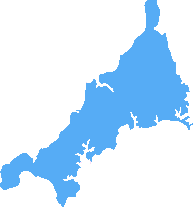
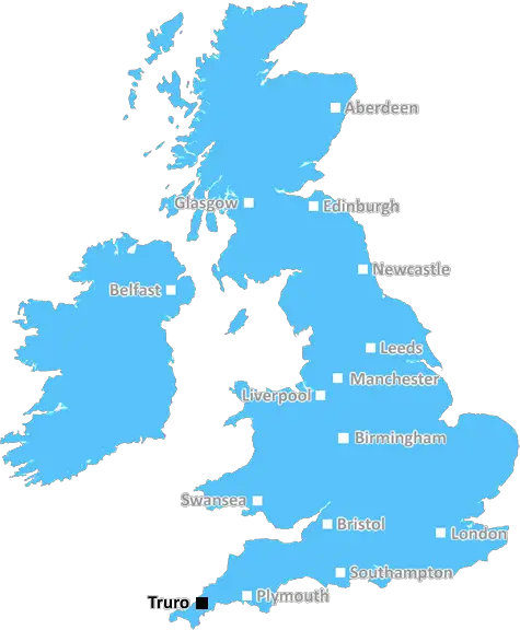
Truro (TR15)
The TR15 postcode area is located in the Truro postcode town region, within the county of Cornwall, and contains a total of 866 individual postcodes.
There are 27 electoral wards in the TR15 postcode area, including Camborne, Falmouth, Hayle, Helston, Isles Of Scilly, Marazion, Newquay, Penryn, Penzance, Perranporth, Redruth, St Agnes, St Columb, St Ives, Truro which come under the local authority of the Cornwall,Isles of Scilly Council.
Combining the whole postcode region, 13% of people in TR15 are classed as having an AB social grade, (i.e. 'white-collar' middle-upper class), compared to 27% across the UK.
This does not mean that the people of TR15 are poorer than other areas, but it may give an indication that there are areas of deprivation.
TR15 is the postcode for the district of Truro in England, located in the county of Cornwall. It covers the city of Truro, located where the rivers Kenwyn and Allen join the River Truro, and its surrounding villages, including Devoran, Chacewater and Kea.
The area is situated along the south coast of Cornwall and is a popular tourist destination. Visitors to TR15 enjoy its stunning beaches, including Roseland, Perranporth, and St Agnes, as well as the nature reserves of Trelissick and Reskajeage Downs. The city is also home to a number of beautiful gardens, such as Trevarno.
TR15 has a vibrant shopping and restaurant scene, with a large selection of independent stores, cafes, and restaurants throughout the centre of the city. There's plenty of culture to experience too, with the Hall for Cornwall theatre, Royal Cornwall Museum, and National Maritime Museum. The home of the famous Duchy of Cornwall, the grade-II listed Truro Cathedral, is also in the district.
Education is excellent in TR15, with two universities, Truro and Falmouth, alongside an extensive selection of primary and secondary schools. The city also benefits from two train stations on the main line from Penzance to London, as well as bus services connecting the area to the rest of Cornwall and beyond.
The surrounding villages offer more laid-back lifestyles, with peaceful streetscapes and views of the coast. The region is filled with other attractions such as the Eden Project and the Lost Gardens of Heligan, and there's plenty of outdoor activities to choose from, from watersports to cycling.
Above all, the TR15 postcode area manages to combine modernity with an agricultural past, offering the best of both worlds. A mix of rolling hills, picturesque villages, ancient ruins and a thriving city centre make TR15 an exciting and varied place to visit and a great place to live.

Demographics

Cornwall
TR15 is located in the county of Cornwall, in England.
Cornwall has a total population of 556,000, making it the 40th largest county in the UK.
Cornwall has a total area of 1375 square miles, and a population density of 156 people per square kilometre. For comparison, Greater London has a density of 5,618 people/km2.
| Outward Code | TR15 |
| Postal Town | Truro |
| MSOA Name | Cornwall 046 |
| LSOA Name | Cornwall 046D |
| County | Cornwall |
| Region | Cornwall |
| Country | England |
| Local Authority | Cornwall,Isles of Scilly |
| Area Classification | Mainly Rural (rural including hub towns >=80%) |
TR15 Electoral Wards
The postal region of TR15, includes the local towns, villages, electoral wards and stations of:
Dig even deeper into the TR15 postcode by clicking on a postcode below:
Click on an outward postal code below for more information about the area. Each 'outward' postcode give you a comprehensive list of all postcodes within the outward code area (TR) and estimated address.
Click on an 'outward' code for more information. For example, the outward postcode page 'EC2M' will give you an alphabetical list covering all postcodes located in the region, from 'EC2M 1BB' through to 'EC2M 7YA'.
Chris H
Wednesday, April 17, 2024
We don't have any views of TR15 right now. If you live in TR15 or have visited it, please help us to help others by telling others what you think of this neighbourhood.
Add your view of TR15
People need your local expertise. If you live in TR15 or have first-hand knowledge of the neighbourhood, please consider sharing your views. It's completely anonymous - all we ask is for your initials.
Please tell us what you like about the TR15 postcode area, what you don't like, and what it's like to live or work here.
| LOCAL AMENITIES | |
| FAMILY FRIENDLY | |
| PARKING | |
| GREEN SPACES |
Local News Cornwall
TikTok social media influencers fly drone over Cornwall naturist beach
A two-man film crew who invaded the privacy of a nudist beach in Cornwall were also filmed flying a drone over the naturist beach after being told to stop vlogging
Cornwall LiveItems worth hundreds of pounds stolen near Liskeard as police launch CCTV appeal
The reported vehicle interference and thefts took place in Pensilva during the early hours of Thursday, February 22
Cornwall LiveSon who slashed mum's throat said he didn't have mental health problem, inquest hears
An inquest into the death of Sally Poynton is being held in Truro
Cornwall LiveWoman's blood vessels so weak they ruptured during surgery
Kate's blood vessels ruptured during the operation from alcohol weakness
Cornwall LiveGlover among five golds for GB at World Rowing Cup
Great Britain finish top of the medal table at the World Rowing Cup in Italy.
BBC News245 homes planned for Wadebridge site to help meet 'demand for affordable homes'
A detailed planning application to finalise the design of the homes will be submitted next before building starts later this year
Cornwall LiveYouth urged to consider effects of knife crime
The family of Michael Riddiough-Allen have set up a charity to educate young people on knife crime.
BBC NewsGordon Ramsay issues squatters with legal papers after they take over 13m pub
Gordon Ramsay has been left fuming after a group of squatters took over his 13 million pub in London and have been using his kitchen appliances to barricade the doors
Cornwall LiveFrom the Postcode Area blog

Deciphering Crime Rates - a Deep Dive Into UK Postcode Analysis
Ever wondered about the crime rate in your UK postcode? You're not alone. We've dug deep into the data, uncovering trends and patterns that'll make your head spin.

Death of the High Street?
The BBC reports that despite councils' attempts to kurb them, the UK's high streets have seen a huge growth in fast food outlets. Could this mark the death knell for the Great British high street, and what can we do about it to halt its decline?

Discrimination by Postcode
You really couldn't make it up, could you? Some of the country's most vulnerable people are missing out on their weekly £25 Cold Weather Payment, just because the system that's in operation is discriminating against them because payments are based on postcode, rather than geographic location.

The Redesign is Underway
Well, the current website was absolutely in dire need of a good redesign - from the ground up. So I set out to pull it all apart and get it up and running again to become the most comprehensive guide to every postcode in the UK. And it's been a long, tough job from start to finish - and quite possibly the biggest project I've ever undertaken.
SOCIAL GRADES
According to census records, 13% of people here have a social grade of AB (highest), compared to the national average of 27%.