oldham OL10 Postcodes
Spending a fortune on conveyancing?

Compare instant, low-cost online quotes from trusted conveyancing solicitors.
Backed by experts, our no-obligation service searches through the best conveyancing quotes on the market to save you time and money.
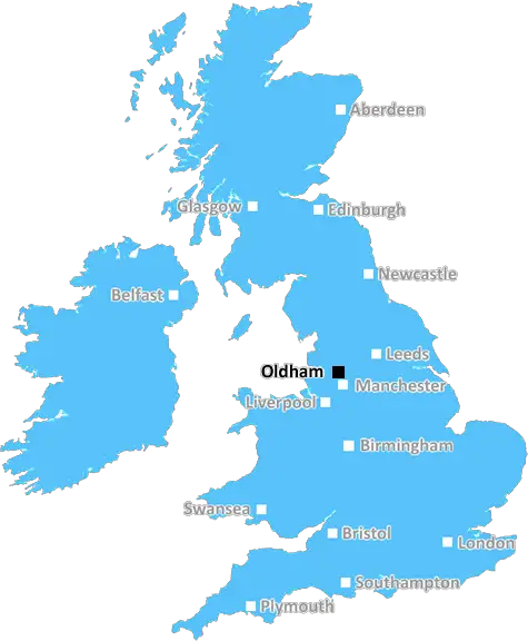
Oldham (OL10)
The OL10 postcode area is located in the Oldham postcode town region, within the county of Greater Manchester, and contains a total of 1079 individual postcodes.
There are 15 electoral wards in the OL10 postcode area, including Ashton-Under-Lyne, Bacup, Heywood, Littleborough, Oldham, Rochdale, Todmorden which come under the local authority of the Rochdale Council.
Combining the whole postcode region, 14% of people in OL10 are classed as having an AB social grade, (i.e. 'white-collar' middle-upper class), compared to 27% across the UK.
This does not mean that the people of OL10 are poorer than other areas, but it may give an indication that there are areas of deprivation.
The OL10 postcode is located in the borough of Oldham, Greater Manchester. The area is bordered by the towns of Rochdale, Heywood, Lees and Shaw. The areas around the postcode saw significant growth in the 19th century when the textile industry flourished. There are now a wide variety of businesses based in the area with their roots still stemming from this industry.
The OL10 postcode is popular with commuters. It has excellent transport links to neighbouring cities, including Manchester, Leeds and Liverpool. Public transport in and around the area is excellent, with plenty of bus services operating throughout the day and night. The area is well connected in terms of rail, with three local stations - Shaw, Derker and Mills Hill - located within a few minutes' walk.
The OL10 postcode also covers a number of different neighbourhoods. These include Shaw, Derker, Milnrow, Failsworth, Denshaw, Diggle and Dobcross. There is a good selection of diverse shops and local amenities, with plenty to explore. These include Aabroo Sanitary Centre, Chenil Veterinary Clinic, Angelina's Traditional Bakery, Anthony's Kitchens and Shree Misthan Bhandar.
The OL10 postcode has a great selection of local schools, ranging from nursery to secondary level. These include St Patrick's Catholic Primary School, Donham Primary School, Mills Hill Primary School, Failsworth Secondary School and St Peter's Catholic High School.
Local leisure facilities include Royton and Crompton Leisure Centre, Rochdale Road Valley Park, King George's Park, and many more. The area is also home to the idyllic Hollingworth Lake Country Park, a large recreational area that offers activities such as canoeing, sailing, fishing and walking trails.
OL10 postcode provides a great base to live in - it offers excellent transport links, plenty of local amenities, lots of recreational activities for all the family, schools, leisure facilities, and more.

Demographics
Greater Manchester

OL10 is located in the county of Greater Manchester, in England.
Greater Manchester has a total population of 2,782,100, making it the 3rd largest county in the UK.
Greater Manchester has a total area of 492 square miles, and a population density of 2180 people per square kilometre. For comparison, Greater London has a density of 5,618 people/km2.
| Outward Code | OL10 |
| Postal Town | Oldham |
| MSOA Name | Rochdale 018 |
| LSOA Name | Rochdale 018B |
| County | Greater Manchester |
| Region | Greater Manchester |
| Country | England |
| Local Authority | Rochdale |
| Area Classification | Urban with Major Conurbation |
OL10 Electoral Wards
The postal region of OL10, includes the local towns, villages, electoral wards and stations of:
Dig even deeper into the OL10 postcode by clicking on a postcode below:
Click on an outward postal code below for more information about the area. Each 'outward' postcode give you a comprehensive list of all postcodes within the outward code area (OL) and estimated address.
Click on an 'outward' code for more information. For example, the outward postcode page 'EC2M' will give you an alphabetical list covering all postcodes located in the region, from 'EC2M 1BB' through to 'EC2M 7YA'.
Chris H
Sunday, April 7, 2024
We don't have any views of OL10 right now. If you live in OL10 or have visited it, please help us to help others by telling others what you think of this neighbourhood.
Add your view of OL10
People need your local expertise. If you live in OL10 or have first-hand knowledge of the neighbourhood, please consider sharing your views. It's completely anonymous - all we ask is for your initials.
Please tell us what you like about the OL10 postcode area, what you don't like, and what it's like to live or work here.
| LOCAL AMENITIES | |
| FAMILY FRIENDLY | |
| PARKING | |
| GREEN SPACES |
Local News Lancashire
Everton beat Burnley to boost survival hopes
Dominic Calvert-Lewin capitalises on an Arijanet Muric error to score his second goal in as many games and help Everton to a priceless win over fellow strugglers Burnley.
BBC NewsSouthampton stumble goes on with draw at Blackburn
Blackburn Rovers hold Southampton to a goalless draw at Ewood Park as Saints fail to win for the third game in a row.
BBC NewsMan 'put through hell' after losing home to DWP
George Henderson said he made an "honest mistake" in claiming too much Carer's Allowance.
BBC NewsMore children and young people getting MMR jab
Health bosses have warned measles 'hasn't gone away', urging people to ensure they are protected.
BBC NewsWatford and Preston play out goalless draw
Watford and Preston play out a relatively drab goalless draw in the Championship.
BBC NewsVolunteer groups at 'crisis point' over NHS referrals
Organisations in Lancashire say they are under pressure due to a rapid increase in "social prescribing".
BBC NewsBritain's loudest birds are booming once again
The RSPB reports ten "booming" males at Leighton Moss - the most on the reserve since the 1990s.
BBC NewsG4 superfan changes her name in honour of singers
Christine Christie Ansell Duncan Jai Martin changed her name in tribute to the X Factor finalists.
BBC NewsFrom the Postcode Area blog

Deciphering Crime Rates - a Deep Dive Into UK Postcode Analysis
Ever wondered about the crime rate in your UK postcode? You're not alone. We've dug deep into the data, uncovering trends and patterns that'll make your head spin.

Death of the High Street?
The BBC reports that despite councils' attempts to kurb them, the UK's high streets have seen a huge growth in fast food outlets. Could this mark the death knell for the Great British high street, and what can we do about it to halt its decline?

Discrimination by Postcode
You really couldn't make it up, could you? Some of the country's most vulnerable people are missing out on their weekly £25 Cold Weather Payment, just because the system that's in operation is discriminating against them because payments are based on postcode, rather than geographic location.

The Redesign is Underway
Well, the current website was absolutely in dire need of a good redesign - from the ground up. So I set out to pull it all apart and get it up and running again to become the most comprehensive guide to every postcode in the UK. And it's been a long, tough job from start to finish - and quite possibly the biggest project I've ever undertaken.
SOCIAL GRADES
According to census records, 14% of people here have a social grade of AB (highest), compared to the national average of 27%.