coventry CV10 Postcodes
Spending a fortune on conveyancing?

Compare instant, low-cost online quotes from trusted conveyancing solicitors.
Backed by experts, our no-obligation service searches through the best conveyancing quotes on the market to save you time and money.
Coventry (CV10)
The CV10 postcode area is located in the Coventry postcode town region, within the county of Warwickshire, and contains a total of 1106 individual postcodes.
There are 31 electoral wards in the CV10 postcode area, including Atherstone, Bedworth, Coventry, Kenilworth, Leamington Spa, Nuneaton, Rugby, Shipston-On-Stour, Southam, Stratford-Upon-Avon, Warwick which come under the local authority of the Nuneaton and Bedworth Council.
Combining the whole postcode region, 14% of people in CV10 are classed as having an AB social grade, (i.e. 'white-collar' middle-upper class), compared to 27% across the UK.
This does not mean that the people of CV10 are poorer than other areas, but it may give an indication that there are areas of deprivation.
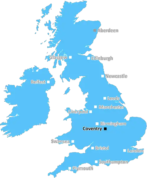
The CV10 postcode is in the Coventry district in the United Kingdom, and covers parts of the towns of Nuneaton and Bedworth. It is bordered by CV11, CV12 and CV9 postcodes.
The postcode generally covers the southern parts of Nuneaton with Chilvers Coton, Attleborough, Church End, Galley Common, and Stockingford within the area. Some parts of Bedworth also fall within the CV10 area, including Rye Piece, Bedworth Heath, Health Hayes, Goodyers End, and Exhall.
The CV10 postcode area is well connected by both road and rail, with major roads such as the A444 and A5, and the Nuneaton-Birmingham railway line passing through it. The area has two junction points of the A444 road - at Church End in Nuneaton and at Telegraph in Bedworth.
The CV10 postcode has a variety of leisure and entertainment options available. One popular destination in the area is the Elephant & Castle pub in Chilvers Coton, which has a restaurant and live music venue, as well as a heated beer garden. The Abbey Theatre in Nuneaton is a popular arts and live entertainment venue, hosting various theatre, dance and music shows.
CV10 is also home to three churches - St Thomas' Church of England in Attleborough, St Joseph's Roman Catholic in Church End, and All Saints' Methodist in Bedworth. Education in the area is covered by a range of state and independent schools, from the Nuneaton Academy to the King Henry VIII Preparatory School.
Nuneaton and Bedworth have a range of shops and supermarkets, with popular retail outlets such as Tesco, Aldi, and Sainsbury's. There is also the Ropewalk Shopping Centre in Nuneaton and the Bedworth Heath Shopping Centre in Bedworth.
Sport and recreation facilities in CV10 include Nuneaton Borough Football Club, the Pingles Leisure Centre, the Bedworth, Exhall & Griff Sports Centre, Kingswood Gold Club, and The Windmill golf course. There are also various parks, nature reserves and other green spaces such as River Anker Nature Park, Hartshill Hayes Country Park, Baddesley Common Nature Reserve, and Sowe Valley Greenway.

Demographics
Warwickshire

CV10 is located in the county of Warwickshire, in England.
Warwickshire has a total population of 556,800, making it the 39th largest county in the UK.
Warwickshire has a total area of 763 square miles, and a population density of 281 people per square kilometre. For comparison, Greater London has a density of 5,618 people/km2.
| Outward Code | CV10 |
| Postal Town | Coventry |
| MSOA Name | Nuneaton and Bedworth 003 |
| LSOA Name | Nuneaton and Bedworth 003C |
| County | Warwickshire |
| Region | Warwickshire |
| Country | England |
| Local Authority | Nuneaton and Bedworth |
| Area Classification | Urban with City and Town |
CV10 Electoral Wards
The postal region of CV10, includes the local towns, villages, electoral wards and stations of:
Dig even deeper into the CV10 postcode by clicking on a postcode below:
Click on an outward postal code below for more information about the area. Each 'outward' postcode give you a comprehensive list of all postcodes within the outward code area (CV) and estimated address.
Click on an 'outward' code for more information. For example, the outward postcode page 'EC2M' will give you an alphabetical list covering all postcodes located in the region, from 'EC2M 1BB' through to 'EC2M 7YA'.
Chris H
Sunday, April 7, 2024
We don't have any views of CV10 right now. If you live in CV10 or have visited it, please help us to help others by telling others what you think of this neighbourhood.
Add your view of CV10
People need your local expertise. If you live in CV10 or have first-hand knowledge of the neighbourhood, please consider sharing your views. It's completely anonymous - all we ask is for your initials.
Please tell us what you like about the CV10 postcode area, what you don't like, and what it's like to live or work here.
| LOCAL AMENITIES | |
| FAMILY FRIENDLY | |
| PARKING | |
| GREEN SPACES |
Local News Warwickshire
Unlocking low carbon adoption: The Warwickshire Business Energy Advice Service
A new Business Energy Advice Service has launched across Warwickshire.
Warwick District CouncilMan arrested over rape of teenager
The suspect is detained following a review of security camera footage.
BBC NewsThe search for merch ahead of Wembley
The market stall that's gearing up with Coventry City merch
BBC NewsPolice hunt after teenager stabbed in face
Warwickshire Police says it has a large presence in Bedworth as officers try to find the suspect.
BBC NewsFunding awarded for solar panels at Newbold Comyn Leisure Centre
Warwick District Council is pleased to announce that it has received 234,000 from phase two of the Sport England Swimming Pool Support Fund to install solar PV panels at Newbold Comyn Leisure Centre.
Warwick District CouncilCastle Farm Leisure Centre hosts successful open day featuring special guest Colin Jackson
Hundreds of people from the local community came along to a free open day on Saturday 24 February to celebrate the official opening of Castle Farm Leisure Centre in Kenilworth.
Warwick District CouncilWarwickshire author goes global
Meet Charlotte, whose book about life as an autistic person is an Amazon bestseller.
BBC NewsRat infestations on the rise in Coventry and Warwickshire
A total of 743 infestations were dealt with every day last year.
BBC NewsFrom the Postcode Area blog

Deciphering Crime Rates - a Deep Dive Into UK Postcode Analysis
Ever wondered about the crime rate in your UK postcode? You're not alone. We've dug deep into the data, uncovering trends and patterns that'll make your head spin.

Death of the High Street?
The BBC reports that despite councils' attempts to kurb them, the UK's high streets have seen a huge growth in fast food outlets. Could this mark the death knell for the Great British high street, and what can we do about it to halt its decline?

Discrimination by Postcode
You really couldn't make it up, could you? Some of the country's most vulnerable people are missing out on their weekly £25 Cold Weather Payment, just because the system that's in operation is discriminating against them because payments are based on postcode, rather than geographic location.

The Redesign is Underway
Well, the current website was absolutely in dire need of a good redesign - from the ground up. So I set out to pull it all apart and get it up and running again to become the most comprehensive guide to every postcode in the UK. And it's been a long, tough job from start to finish - and quite possibly the biggest project I've ever undertaken.
SOCIAL GRADES
According to census records, 14% of people here have a social grade of AB (highest), compared to the national average of 27%.