nottingham NG17 Postcodes
Spending a fortune on conveyancing?

Compare instant, low-cost online quotes from trusted conveyancing solicitors.
Backed by experts, our no-obligation service searches through the best conveyancing quotes on the market to save you time and money.
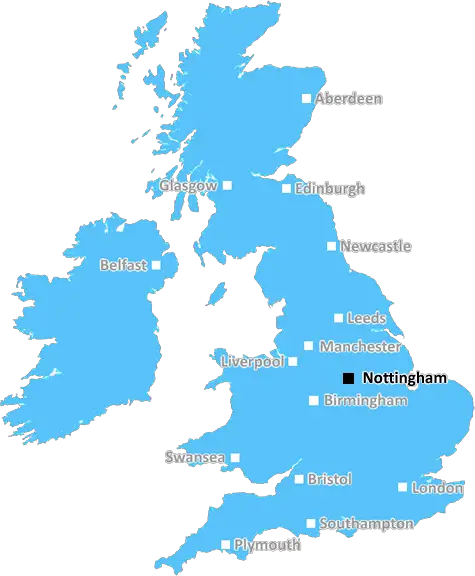
Nottingham (NG17)
The NG17 postcode area is located in the Nottingham postcode town region, within the county of Nottinghamshire, and contains a total of 1879 individual postcodes.
There are 27 electoral wards in the NG17 postcode area, including Grantham, Mansfield, Newark, Nottingham, Sleaford, Southwell, Sutton-In-Ashfield which come under the local authority of the Ashfield Council.
Combining the whole postcode region, 12% of people in NG17 are classed as having an AB social grade, (i.e. 'white-collar' middle-upper class), compared to 27% across the UK.
This does not mean that the people of NG17 are poorer than other areas, but it may give an indication that there are areas of deprivation.
NG17 is a postcode district located in Nottinghamshire, which is part of the larger Nottingham postcode area. It covers the northwestern parts of the city of Nottingham and small portions of the surrounding towns and villages, including Papplewick, Ravenshead, Sutton in Ashfield, Bleasby, Annesley, Oxton, Huthwaite, Newstead Village and Wigwam Lane.
The postcode district also includes parts of the Sherwood Forest National Nature Reserve, the Warsop Golf Club, and the Nottinghamshire County Showground.
The district is a major manufacturing and retail area in Nottinghamshire, and is home to many well-known companies such as Boots, Kimberley-Clark, Siemens, and Carlsberg. It is also home to many great attractions such as Sherwood Forest, the National Watersports Centre, and the National Ice Centre.
The M1 motorway runs through the district, and is served by the A61 and A614 roads. The Robin Hood Line also links the district to other parts of Nottinghamshire, with stops at Papplewick, Bleasby, Oxton, and Ravenshead.
The district has a population of nearly 19,000, and average living wages are the 3rd highest in the East Midlands. The median house prices in the postcode district are significantly higher than the localised Nottingham average and the national average, and are in the range of �220,000 to �250,000.
In terms of schooling, the district is served by a number of primary, secondary, and independent schools including St Peter and St Paul Church of England Primary School, Sutton Community Academy, and Charles Read Academy.
In terms of leisure, the district has a wide range of amenities such as golf courses, parks, football clubs, food outlets and pubs. It is also home to both a Cineworld and an Odeon cinema. A number of arts and cultural venues such as Theatre Royal and Nottingham Playhouse are also located in the postcode area.

Demographics

Nottinghamshire

NG17 is located in the county of Nottinghamshire, in England.
Nottinghamshire has a total population of 1,136,000, making it the 15th largest county in the UK.
Nottinghamshire has a total area of 834 square miles, and a population density of 526 people per square kilometre. For comparison, Greater London has a density of 5,618 people/km2.
| Outward Code | NG17 |
| Postal Town | Nottingham |
| MSOA Name | Ashfield 005 |
| LSOA Name | Ashfield 005E |
| County | Nottinghamshire |
| Region | Nottinghamshire |
| Country | England |
| Local Authority | Ashfield |
| Area Classification | Urban with City and Town |
NG17 Electoral Wards
The postal region of NG17, includes the local towns, villages, electoral wards and stations of:
Dig even deeper into the NG17 postcode by clicking on a postcode below:
Click on an outward postal code below for more information about the area. Each 'outward' postcode give you a comprehensive list of all postcodes within the outward code area (NG) and estimated address.
Click on an 'outward' code for more information. For example, the outward postcode page 'EC2M' will give you an alphabetical list covering all postcodes located in the region, from 'EC2M 1BB' through to 'EC2M 7YA'.
AD, nottingham
Friday, February 15, 2019
There's a park close by, local transport links for bus and train. There's a corner shop within a few minutes walk. The nearest school, town and doctors is half an hour's walk. This area is a desirable location to live
Add your view of NG17
People need your local expertise. If you live in NG17 or have first-hand knowledge of the neighbourhood, please consider sharing your views. It's completely anonymous - all we ask is for your initials.
Please tell us what you like about the NG17 postcode area, what you don't like, and what it's like to live or work here.
| LOCAL AMENITIES | |
| FAMILY FRIENDLY | |
| PARKING | |
| GREEN SPACES |
Local News Nottinghamshire
Grace O'Malley-Kumar's father describes 'role model' daughter amid George Cross campaign
It could be at least 18 months before a final decision is made on whether to award Grace a George Cross
Nottingham PostNottingham attacks victim honoured at hockey event
A charity tournament is organised in memory of Grace O'Malley-Kumar, who was killed last June.
BBC NewsMan moving into Mansfield home has bags stolen by dog walker
Police would like to speak to this man in connection with the Rosemary Street incident
Nottingham PostRare Pokmon card collection could sell for 25k
The sets include some which feature not only every card but every variant of every card.
BBC NewsGary Godden elected as Nottinghamshire PCC
He earned 119,355 votes, beating Caroline Henry who was elected for the Conservatives in 2021.
BBC NewsForest should have had one penalty at Everton - panel
Nottingham Forest should have been awarded one penalty from their three unsuccessful appeals at Everton, an independent panel says.
BBC NewsCCTV appeal after bags stolen from man moving home
Police say a passing dog walker picked up the items in a "brazen theft".
BBC News9 jobs in Nottingham city centre you can apply for right now
Fancy working at the Paul Smith shop or even at a city sports bar?
Nottingham PostFrom the Postcode Area blog

Deciphering Crime Rates - a Deep Dive Into UK Postcode Analysis
Ever wondered about the crime rate in your UK postcode? You're not alone. We've dug deep into the data, uncovering trends and patterns that'll make your head spin.

Death of the High Street?
The BBC reports that despite councils' attempts to kurb them, the UK's high streets have seen a huge growth in fast food outlets. Could this mark the death knell for the Great British high street, and what can we do about it to halt its decline?

Discrimination by Postcode
You really couldn't make it up, could you? Some of the country's most vulnerable people are missing out on their weekly £25 Cold Weather Payment, just because the system that's in operation is discriminating against them because payments are based on postcode, rather than geographic location.

The Redesign is Underway
Well, the current website was absolutely in dire need of a good redesign - from the ground up. So I set out to pull it all apart and get it up and running again to become the most comprehensive guide to every postcode in the UK. And it's been a long, tough job from start to finish - and quite possibly the biggest project I've ever undertaken.
SOCIAL GRADES
According to census records, 12% of people here have a social grade of AB (highest), compared to the national average of 27%.