norwich NR16 Postcodes
Spending a fortune on conveyancing?

Compare instant, low-cost online quotes from trusted conveyancing solicitors.
Backed by experts, our no-obligation service searches through the best conveyancing quotes on the market to save you time and money.
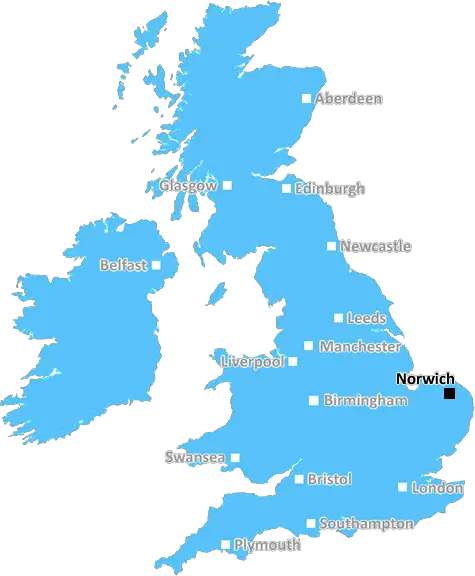
Norwich (NR16)
The NR16 postcode area is located in the Norwich postcode town region, within the county of Norfolk, and contains a total of 545 individual postcodes.
There are 99 electoral wards in the NR16 postcode area, including Attleborough, Beccles, Bungay, Cromer, Dereham, Fakenham, Great Yarmouth, Holt, Lowestoft, Melton Constable, North Walsham, Norwich, Sheringham, Walsingham, Wells-Next-The-Sea, Wymondham which come under the local authority of the South Norfolk Council.
Combining the whole postcode region, 23% of people in NR16 are classed as having an AB social grade, (i.e. 'white-collar' middle-upper class), compared to 27% across the UK.
This does not mean that the people of NR16 are poorer than other areas, but it may give an indication that there are areas of deprivation.
The NR16 postcode is part of the Norwich district in the UK. It is a suburban area located east of the historic city of Norwich. It borders the villages of Tibenham, Morningthorpe, Stratton Strawless, Felthorpe, and High Green. It is situated within the civil parish of South Norwich.
NR16 postcode is home to several schools and educational institutions. These include Old Hall Primary School, South Walsham Primary School, High Green Primary School, and Norwich International Centre for Education. Nearby secondary schools include Notre Dame High School, Sprowston Community High School and Sir Isaac Newton Sixth Form College.
Various recreational and leisure activities are available around the NR16 area. The city of Norwich offers a range of entertainment, from art galleries to theatres, and shopping streets to restaurants. Furthermore, the nearby Broadland-Riverside Walk lets visitors take in the scenery of the Norfolk BroadsNational Park. In addition, local attractions include the historic Tharston Hall, the Horsford Woods activity centre, and the Taverham Mill Garden Centre.
The area also has numerous medical and health centres. These include the Humber Centre, the City Health Centre, and the Norwich and Norfolk Hospital. The NR16 postcode is well connected by public transport, with regular bus and train services to the city centre.
The NR16 has various green spaces, such as The Plantation, The Common, The Paddocks, and Horsford Woods. The area has a number of parks, sporting facilities and leisure centres, such as Muscle Building Gym, Fitness First, and David Lloyd Centre. It also has a range of churches, including the Methodist, Anglican, Catholic, and Church of England congregations. It is served by a number of pubs and restaurants, often located near the river.

Demographics

Norfolk

NR16 is located in the county of Norfolk, in England.
Norfolk has a total population of 892,900, making it the 25th largest county in the UK.
Norfolk has a total area of 2080 square miles, and a population density of 165 people per square kilometre. For comparison, Greater London has a density of 5,618 people/km2.
| Outward Code | NR16 |
| Postal Town | Norwich |
| MSOA Name | South Norfolk 011 |
| LSOA Name | South Norfolk 011C |
| County | Norfolk |
| Region | Norfolk |
| Country | England |
| Local Authority | South Norfolk |
| Area Classification | Mainly Rural (rural including hub towns >=80%) |
NR16 Electoral Wards
The postal region of NR16, includes the local towns, villages, electoral wards and stations of:
Dig even deeper into the NR16 postcode by clicking on a postcode below:
Click on an outward postal code below for more information about the area. Each 'outward' postcode give you a comprehensive list of all postcodes within the outward code area (NR) and estimated address.
Click on an 'outward' code for more information. For example, the outward postcode page 'EC2M' will give you an alphabetical list covering all postcodes located in the region, from 'EC2M 1BB' through to 'EC2M 7YA'.
Chris H
Sunday, April 7, 2024
We don't have any views of NR16 right now. If you live in NR16 or have visited it, please help us to help others by telling others what you think of this neighbourhood.
Add your view of NR16
People need your local expertise. If you live in NR16 or have first-hand knowledge of the neighbourhood, please consider sharing your views. It's completely anonymous - all we ask is for your initials.
Please tell us what you like about the NR16 postcode area, what you don't like, and what it's like to live or work here.
| LOCAL AMENITIES | |
| FAMILY FRIENDLY | |
| PARKING | |
| GREEN SPACES |
Local News Norfolk
Access to NHS dentists 'still a concern' in county
A patient group finds practices have waiting lists of up to 6,000 people.
BBC NewsCharity hopes 'Big Bum' fundraiser will attract hundreds
The organisation is hosting events at the weekend to highlight the symptoms of bowel cancer.
BBC NewsChildren's hospital celebrates 170th anniversary
Jenny Lind Children's Hospital has become a "renowned specialist centre", its chair says.
BBC NewsPolice investigate death of man found on beach
While the man's death is unexplained, police do not believe it to be suspicious.
BBC NewsSeven arrested after protest at pork factory
Police deal with an ongoing incident, which the company describes as "criminal".
BBC NewsNorwich beat Ipswich in East Anglian derby
Ipswich Town are overtaken by Leicester at the top of the Championship following defeat by Norwich City in the East Anglian derby.
BBC NewsFans urged to check train times before derby match
Ipswich fans going to Norwich could be affected by timetable changes due to strike action.
BBC NewsThe Great Escapee memento found in a cupboard
A Gresham School swagger stick owned by a wartime escapee is found in an airing cupboard.
BBC NewsFrom the Postcode Area blog

Deciphering Crime Rates - a Deep Dive Into UK Postcode Analysis
Ever wondered about the crime rate in your UK postcode? You're not alone. We've dug deep into the data, uncovering trends and patterns that'll make your head spin.

Death of the High Street?
The BBC reports that despite councils' attempts to kurb them, the UK's high streets have seen a huge growth in fast food outlets. Could this mark the death knell for the Great British high street, and what can we do about it to halt its decline?

Discrimination by Postcode
You really couldn't make it up, could you? Some of the country's most vulnerable people are missing out on their weekly £25 Cold Weather Payment, just because the system that's in operation is discriminating against them because payments are based on postcode, rather than geographic location.

The Redesign is Underway
Well, the current website was absolutely in dire need of a good redesign - from the ground up. So I set out to pull it all apart and get it up and running again to become the most comprehensive guide to every postcode in the UK. And it's been a long, tough job from start to finish - and quite possibly the biggest project I've ever undertaken.
SOCIAL GRADES
According to census records, 23% of people here have a social grade of AB (highest), compared to the national average of 27%.