exeter EX33 Postcodes
Spending a fortune on conveyancing?

Compare instant, low-cost online quotes from trusted conveyancing solicitors.
Backed by experts, our no-obligation service searches through the best conveyancing quotes on the market to save you time and money.
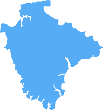
Exeter (EX33)
The EX33 postcode area is located in the Exeter postcode town region, within the county of Devon, and contains a total of 413 individual postcodes.
There are 26 electoral wards in the EX33 postcode area, including Axminster, Barnstaple, Beaworthy, Bideford, Braunton, Bude, Budleigh Salterton, Chulmleigh, Colyton, Crediton, Cullompton, Dawlish, Exeter, Exmouth, Holsworthy, Honiton, Ilfracombe, Lynmouth, Lynton, North Tawton, Okehampton, Ottery St Mary, Seaton, Sidmouth, South Molton, Tiverton, Torrington, Umberleigh, Winkleigh, Woolacombe which come under the local authority of the North Devon Council.
Combining the whole postcode region, 22% of people in EX33 are classed as having an AB social grade, (i.e. 'white-collar' middle-upper class), compared to 27% across the UK.
This does not mean that the people of EX33 are poorer than other areas, but it may give an indication that there are areas of deprivation.
EX33 is a postcode district in the UK located in the North Devon district of England. It covers the geographical area surrounding the village of High Bickington, as well as the nearby villages of East Allington, Shirwell, Watermouth, Berrynarbor, and Georgeham.
The postcode is originated at the Howden Delivery Office, and is split into two smaller postcode areas - EX33 0 and EX33 9. All of the postcode district area is within the electoral ward of Chittlehampton, which is part of the Barnstaple North Division of Devon County Council.
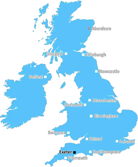
EX33 is just within 1 hour drive from the city of Exeter and 31 miles north from the major city of Plymouth. This area is also very close to the coast, with the famous surfing spot of Croyde beach and celebrated walkers' destination of Exmoor National Park all within easy reach.
The North Devon Area of Outstanding Natural Beauty (AONB) is renowned for its amazing coastline, with its breathtakingly beautiful beaches that remain relatively secluded. It also has a stunning array of countryside, including fields of wildflower meadows, woodlands filled with wildlife, and rolling hills which are perfect for walking.
Much of the local area within the EX33 postcode is owned by National Trust, where visitors are able to enjoy walking, bird watching, picnicking, and a variety of other outdoor activities. Nearby Exmoor National Park is also popular for its hiking trails and mountain bike routes. Furthermore, a wealth of pubs, restaurants, cafes, galleries, and other interesting sights can be found close to the postcode boundaries.
The villages within the EX33 postcode are characterised by narrow lanes, quaint cottages, and country pubs, making for a wonderfully rural atmosphere. This area is perfect for those seeking to escape from the hustle and bustle, with many working farms still operational in this part of Devon. Moreover, it is home to an array of local independent shops, businesses and services.

Demographics
Devon
EX33 is located in the county of Devon, in England.
Devon has a total population of 1,177,900, making it the 11th largest county in the UK.
Devon has a total area of 2589 square miles, and a population density of 175 people per square kilometre. For comparison, Greater London has a density of 5,618 people/km2.
| Outward Code | EX33 |
| Postal Town | Exeter |
| MSOA Name | North Devon 005 |
| LSOA Name | North Devon 005D |
| County | Devon |
| Region | Devon |
| Country | England |
| Local Authority | North Devon |
| Area Classification | Largely Rural (rural including hub towns 50-79%) |
EX33 Electoral Wards
The postal region of EX33, includes the local towns, villages, electoral wards and stations of:
Dig even deeper into the EX33 postcode by clicking on a postcode below:
Click on an outward postal code below for more information about the area. Each 'outward' postcode give you a comprehensive list of all postcodes within the outward code area (EX) and estimated address.
Click on an 'outward' code for more information. For example, the outward postcode page 'EC2M' will give you an alphabetical list covering all postcodes located in the region, from 'EC2M 1BB' through to 'EC2M 7YA'.
Chris H
Saturday, May 11, 2024
We don't have any views of EX33 right now. If you live in EX33 or have visited it, please help us to help others by telling others what you think of this neighbourhood.
Add your view of EX33
People need your local expertise. If you live in EX33 or have first-hand knowledge of the neighbourhood, please consider sharing your views. It's completely anonymous - all we ask is for your initials.
Please tell us what you like about the EX33 postcode area, what you don't like, and what it's like to live or work here.
| LOCAL AMENITIES | |
| FAMILY FRIENDLY | |
| PARKING | |
| GREEN SPACES |
Local News Devon
Diver loses consciousness in the sea in Plymouth Sound and sparks large-scale emergency response
Both a Coastguard helicopter and a Devon Air Ambulance were called to the waterfront alongside the RNLI and paramedics.
Plymouth LiveJust Stop Oil pair guilty over Crucible protest
Eddie Whittingham and Margaret Reid are found guilty following a one-day trial in Sheffield.
BBC NewsPeople 'heartbroken' over Plymouth vegan cafe closure
The well known cafe in Plymouth city centre will close its doors after this weekend
Plymouth LiveGalloway and Miller offered new Plymouth Argyle deals
Plymouth Argyle are continuing contract talks with defenders Brendan Galloway and Mikel Miller.
BBC NewsWork held up on Plymouth trees regeneration site
Plymouth City Council says work has stopped due to a legal appeal but campaigners deny that.
BBC NewsEpic scale of former Mayflower Medical Group GP redundancies now revealed
Documents show 35% of staff are set to lose jobs at group of five Plymouth surgeries after 5,000 patients leave
Plymouth LiveLIVE: Attempted murder arrest in Plymouth after suspected stabbing
Police have confirmed they are on the scene and a knife has been seized
Plymouth Live'Heaths to sea' scheme gets funding boost
A project aimed at improving Lower Otter Valley in east Devon is awarded government funding.
BBC NewsFrom the Postcode Area blog

Deciphering Crime Rates - a Deep Dive Into UK Postcode Analysis
Ever wondered about the crime rate in your UK postcode? You're not alone. We've dug deep into the data, uncovering trends and patterns that'll make your head spin.

Death of the High Street?
The BBC reports that despite councils' attempts to kurb them, the UK's high streets have seen a huge growth in fast food outlets. Could this mark the death knell for the Great British high street, and what can we do about it to halt its decline?

Discrimination by Postcode
You really couldn't make it up, could you? Some of the country's most vulnerable people are missing out on their weekly £25 Cold Weather Payment, just because the system that's in operation is discriminating against them because payments are based on postcode, rather than geographic location.

The Redesign is Underway
Well, the current website was absolutely in dire need of a good redesign - from the ground up. So I set out to pull it all apart and get it up and running again to become the most comprehensive guide to every postcode in the UK. And it's been a long, tough job from start to finish - and quite possibly the biggest project I've ever undertaken.
SOCIAL GRADES
According to census records, 22% of people here have a social grade of AB (highest), compared to the national average of 27%.