dumfries DG10 Postcodes
Spending a fortune on conveyancing?

Compare instant, low-cost online quotes from trusted conveyancing solicitors.
Backed by experts, our no-obligation service searches through the best conveyancing quotes on the market to save you time and money.
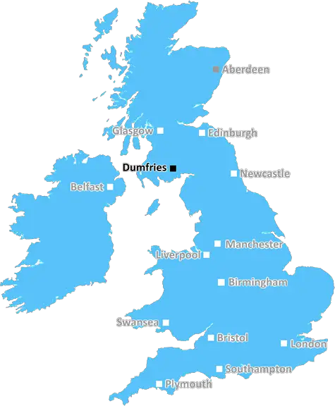
Dumfries (DG10)
The DG10 postcode area is located in the Dumfries postcode town region, within the county of Dumfriesshire, and contains a total of 245 individual postcodes.
There are 19 electoral wards in the DG10 postcode area, including Annan, Canonbie, Castle Douglas, Dalbeattie, Dumfries, Gretna, Kirkcudbright, Langholm, Lockerbie, Moffat, Newton Stewart, Sanquhar, Stranraer, Thornhill which come under the local authority of the Dumfries & Galloway Council.
Combining the whole postcode region, 0% of people in DG10 are classed as having an AB social grade, (i.e. 'white-collar' middle-upper class), compared to 27% across the UK.
This does not mean that the people of DG10 are poorer than other areas, but it may give an indication that there are areas of deprivation.
DG10 is a postcode district in the area of Dumfries, Scotland. It covers an area of approximately 720 square kilometres from Lockerbie in the east to Thornhill in the south and to Gatehouse in the west.
The DG10 postcode consists of parts of the towns of Lockerbie and Thornhill and other small villages such as Kirkpatrick, Netherwitton, Durisdeer, Kirkmahoe, Closeburn, and Lockberbie. The postcode is serviced by the Royal Mail postcode area code of DG for Dumfries.
The Major Towns in the area are Lockerbie and Thornhill, with Lockerbie town having the largest population. The postcode is made up of areas of mainly rural terrain, with parts of the towns of Thornhill and Lockerbie. Although the DG10 postcode may cover a large area, its population is only roughly around 11,000 people.
The area is served by two secondary schools, Lockerbie Academy and Thornhill Academy. Other education facilities include a private school, Lockerbie Prep School, and a further education college, Dumfries and Galloway College.
Shopping is well catered for in the major towns of Lockerbie and Thornhill. Shopping amenities include supermarkets, banks, pharmacies, post offices, libraries, and small independent shops. There are several small local food shops, fishmongers, greengrocers, bakeries, and butchers.
The area has a variety of leisure, outdoor, and sports activities. Lockerbie Public Park, located in Lockerbie Town Centre, offers facilities such as a theatre, bowling green, children's play area, and a pond. Other nearby parks include Kirkpatrick, Torr, and Carruthers Memorial Park which are all situated in Lockerbie Town Centre.
The area offers some stunning scenery and spectacular views. There are many great walks and cycle routes and visitors can enjoy hills, forests, lochs, and quaint villages. The area is also home to several golf courses as well as fishing and shooting activities.
DG10 has excellent access to Scotland's motorway network and is within an hour's drive to Glasgow, Edinburgh and Carlisle. A direct train line from Lockerbie to London King's Cross makes it easy to get about. Holiday makers can easily reach the beautiful areas of the Lake District, the Scottish Borders, and the Highlands from DG10.

Demographics
Dumfriesshire

DG10 is located in the county of Dumfriesshire, in Scotland.
Dumfriesshire has a total population of 0, making it the largest county in the UK.
Dumfriesshire has a total area of square miles, and a population density of people per square kilometre. For comparison, Greater London has a density of 5,618 people/km2.
| Outward Code | DG10 |
| Postal Town | Dumfries |
| MSOA Name | Moffat and Eskdalemuir |
| LSOA Name | |
| County | Dumfriesshire |
| Region | Dumfriesshire |
| Country | Scotland |
| Local Authority | Dumfries & Galloway |
| Area Classification | Unclassified |
DG10 Electoral Wards
The postal region of DG10, includes the local towns, villages, electoral wards and stations of:
Dig even deeper into the DG10 postcode by clicking on a postcode below:
Click on an outward postal code below for more information about the area. Each 'outward' postcode give you a comprehensive list of all postcodes within the outward code area (DG) and estimated address.
Click on an 'outward' code for more information. For example, the outward postcode page 'EC2M' will give you an alphabetical list covering all postcodes located in the region, from 'EC2M 1BB' through to 'EC2M 7YA'.
Chris H
Monday, April 8, 2024
We don't have any views of DG10 right now. If you live in DG10 or have visited it, please help us to help others by telling others what you think of this neighbourhood.
Add your view of DG10
People need your local expertise. If you live in DG10 or have first-hand knowledge of the neighbourhood, please consider sharing your views. It's completely anonymous - all we ask is for your initials.
Please tell us what you like about the DG10 postcode area, what you don't like, and what it's like to live or work here.
| LOCAL AMENITIES | |
| FAMILY FRIENDLY | |
| PARKING | |
| GREEN SPACES |
From the Postcode Area blog

Deciphering Crime Rates - a Deep Dive Into UK Postcode Analysis
Ever wondered about the crime rate in your UK postcode? You're not alone. We've dug deep into the data, uncovering trends and patterns that'll make your head spin.

Death of the High Street?
The BBC reports that despite councils' attempts to kurb them, the UK's high streets have seen a huge growth in fast food outlets. Could this mark the death knell for the Great British high street, and what can we do about it to halt its decline?

Discrimination by Postcode
You really couldn't make it up, could you? Some of the country's most vulnerable people are missing out on their weekly £25 Cold Weather Payment, just because the system that's in operation is discriminating against them because payments are based on postcode, rather than geographic location.

The Redesign is Underway
Well, the current website was absolutely in dire need of a good redesign - from the ground up. So I set out to pull it all apart and get it up and running again to become the most comprehensive guide to every postcode in the UK. And it's been a long, tough job from start to finish - and quite possibly the biggest project I've ever undertaken.
SOCIAL GRADES
According to census records, 0% of people here have a social grade of AB (highest), compared to the national average of 27%.