crewe CW7 Postcodes
Spending a fortune on conveyancing?

Compare instant, low-cost online quotes from trusted conveyancing solicitors.
Backed by experts, our no-obligation service searches through the best conveyancing quotes on the market to save you time and money.
Crewe (CW7)
The CW7 postcode area is located in the Crewe postcode town region, within the county of Cheshire, and contains a total of 1145 individual postcodes.
There are 30 electoral wards in the CW7 postcode area, including Congleton, Crewe, Middlewich, Nantwich, Northwich, Sandbach, Tarporley, Winsford which come under the local authority of the Cheshire West and Chester Council.
Combining the whole postcode region, 17% of people in CW7 are classed as having an AB social grade, (i.e. 'white-collar' middle-upper class), compared to 27% across the UK.
This does not mean that the people of CW7 are poorer than other areas, but it may give an indication that there are areas of deprivation.
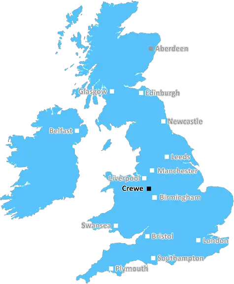
The CW7 postcode district is usually referred to as the Crewe postcode area. It is a geographical area based around the town of Crewe in the Cheshire East area of England. The district covers an area which is 8 miles east of Congleton to the north, 14 miles south of Chester, 10 miles west of Macclesfield and 10 miles east of Nantwich.
The CW7 postcode district covers around forty-two square kilometres and includes the villages of Barthomley, Haslington, Odd Rode, Hough, Radway Green, Alsager, Balterley, Wheelock and Sound. It is bordered by the Cheshire postcode districts of CW5 to the west and CW8 to the east, and by Staffordshire postcode districts for ST7 and ST7 in the south and east respectively.
The postcode district is mainly residential with some agricultural activity and some light industry. Many of the areas previously served by the railway are now of historical interest and are mainly used as recreational areas.
According to 2011 census data, the population of Crewe is around 68,222, with around 57% of those being aged under 45. The area is mainly middle-class with a relatively balanced occupation base, which includes many professional and skilled occupations. Average wages are below the national average, however.
Crewe Station is amongst one of London Northwestern rail's key service points and Crewe also falls under the West Coast Main Line and Manchester to Crewe rail line, making it a hub for train services in the area. There are also many bus services connecting the district with other nearby towns, as well as two railway museum sites and a green area known as Queen's Park.
The district has one higher educational establishment, the South Cheshire College, and several primary and secondary schools, including the popular St Thomas More Catholic Primary School. There are also many retail and leisure areas within and around the town, including the newly developed Grand Junction Retail Park, alongside Queensway Shopping Centre, which serves the town centre.

Demographics
Cheshire

CW7 is located in the county of Cheshire, in England.
Cheshire has a total population of 1,048,100, making it the 19th largest county in the UK.
Cheshire has a total area of 904 square miles, and a population density of 447 people per square kilometre. For comparison, Greater London has a density of 5,618 people/km2.
| Outward Code | CW7 |
| Postal Town | Crewe |
| MSOA Name | Cheshire West and Chester 042 |
| LSOA Name | Cheshire West and Chester 042A |
| County | Cheshire |
| Region | Cheshire |
| Country | England |
| Local Authority | Cheshire West and Chester |
| Area Classification | Urban with Significant Rural (rural including hub towns 26-49%) |
CW7 Electoral Wards
The postal region of CW7, includes the local towns, villages, electoral wards and stations of:
Dig even deeper into the CW7 postcode by clicking on a postcode below:
Click on an outward postal code below for more information about the area. Each 'outward' postcode give you a comprehensive list of all postcodes within the outward code area (CW) and estimated address.
Click on an 'outward' code for more information. For example, the outward postcode page 'EC2M' will give you an alphabetical list covering all postcodes located in the region, from 'EC2M 1BB' through to 'EC2M 7YA'.
Chris H
Thursday, April 11, 2024
We don't have any views of CW7 right now. If you live in CW7 or have visited it, please help us to help others by telling others what you think of this neighbourhood.
Add your view of CW7
People need your local expertise. If you live in CW7 or have first-hand knowledge of the neighbourhood, please consider sharing your views. It's completely anonymous - all we ask is for your initials.
Please tell us what you like about the CW7 postcode area, what you don't like, and what it's like to live or work here.
| LOCAL AMENITIES | |
| FAMILY FRIENDLY | |
| PARKING | |
| GREEN SPACES |
From the Postcode Area blog

Deciphering Crime Rates - a Deep Dive Into UK Postcode Analysis
Ever wondered about the crime rate in your UK postcode? You're not alone. We've dug deep into the data, uncovering trends and patterns that'll make your head spin.

Death of the High Street?
The BBC reports that despite councils' attempts to kurb them, the UK's high streets have seen a huge growth in fast food outlets. Could this mark the death knell for the Great British high street, and what can we do about it to halt its decline?

Discrimination by Postcode
You really couldn't make it up, could you? Some of the country's most vulnerable people are missing out on their weekly £25 Cold Weather Payment, just because the system that's in operation is discriminating against them because payments are based on postcode, rather than geographic location.

The Redesign is Underway
Well, the current website was absolutely in dire need of a good redesign - from the ground up. So I set out to pull it all apart and get it up and running again to become the most comprehensive guide to every postcode in the UK. And it's been a long, tough job from start to finish - and quite possibly the biggest project I've ever undertaken.
SOCIAL GRADES
According to census records, 17% of people here have a social grade of AB (highest), compared to the national average of 27%.